|
||

|

|
|

|
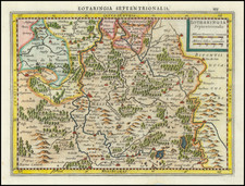
This map offers a detailed cartographic depiction of the duchies of Lorraine and Bar, along with the bishoprics of Metz, Toul, and Verdun.
Produced in the early 18th century, this map reflects the complex political landscape of the Holy Roman Empire and the intricate territorial divisions of the region.
In the first half of the 18th century, the region of Lorraine (Lotharingia) was a significant area in Central Europe, marked by its strategic location and political importance. Historically a duchy within the Holy Roman Empire, Lorraine frequently found itself at the crossroads of European power struggles. The Duchy of Bar, adjacent to Lorraine, shared a similar history of fluctuating sovereignty and territorial disputes. Major cities within the region include Nancy, the capital of the Duchy of Lorraine, and Metz, a key ecclesiastical and administrative center.
The bishoprics of Metz, Toul, and Verdun, known as the Three Bishoprics, were significant ecclesiastical territories that had been annexed by France in the mid-16th century but were still depicted in maps of the Holy Roman Empire due to their historical ties. These regions are characterized by their fortified cities, religious significance, and economic activity.
Prominent rivers such as the Moselle and the Meuse flow through this area, providing critical waterways for trade and transportation, and enhancing the strategic value of the territories.
The cartouche of this map is richly decorated with allegorical figures that symbolize the region's characteristics and its political status. The central figure, a warrior clad in classical armor, likely represents the martial spirit and historical conflicts of Lorraine. Surrounding this figure are other allegorical elements, including a river god symbolizing the region's abundant waterways and a cherub holding a shield adorned with Lorraine's coat of arms.
This artistic embellishment serves not only as a decorative element but also conveys the significance and prestige of the region. The cherub and classical motifs emphasize the historical depth and the cultural heritage of Lorraine and its surrounding territories. Homann's use of such detailed allegorical imagery reflects the Baroque style prevalent in cartography of the period, where maps were both practical tools and works of art.
Johann Baptist Homann (1663-1724) was a mapmaker who founded the famous Homann Heirs publishing company. He lived his entire life in Bavaria, particularly in Nuremberg. Initially, Johann trained to become a priest before converting to Protestantism and working as a notary.
In 1702, Johann founded a publishing house that specialized in engravings. The firm flourished, becoming the leading map publisher in Germany and an important entity in the European map market. In 1715, Johann was named Imperial Geographer to the Holy Roman Empire by Charles VI and made a member of the Prussian Academy of Sciences. Most importantly for his business, his reputation and contacts gained him imperial printing privileges which protected his publications and recommended him to customers. Johann is best known for this Grosser Atlas ueber die ganze Welt, or the Grand Atlas of the World, published in 1716.
After Johann died in 1724, the business passed to his son, Christoph (1703-1730). Upon Christoph’s early death, the company passed to subsequent heirs, with the name of the company changing to Homann Erben, or Homann Heirs. The firm continued in business until 1848.
![[ Paris - Soissons - Champagne / area between the Seine River, Oise, River, Aisne River and Marne Rivers ]](https://storage.googleapis.com/raremaps/img/small/90932.jpg)