|
||

|

|
|

|
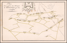
Attractive map of Boulogne-sur-Mer in northern France, with south-oriented at the top. The map shows the 18th-century layout of the city, with an older elevated part of the city and a younger coastal part. Detail is extensive, with topography, rivers, and roads shown, and maritime detail includes soundings and sandbanks.
Boulogne-sur-Mer was always an important naval port due to its proximity to the British Isles and was a center of conflict during the Middle Ages, the Napoleonic Wars, and the World Wars. The city would see notable growth and investment during the 18th and 19th centuries when conflict between France and England was at its highest.
The map appeared in Jacques Nicolas Bellin's Le Petit Atlas Maritime Recueti de Cartes et Plans des Quatre Parlies du Monde en Cinq Volumes, first published in Paris in 1764. The Atlas was an important 5 volume work, showing many places of interest around the world.
Jacques-Nicolas Bellin (1703-1772) was among the most important mapmakers of the eighteenth century. In 1721, at only the age of 18, he was appointed Hydrographer to the French Navy. In August 1741, he became the first Ingénieur de la Marine of the Dépôt des cartes et plans de la Marine (the French Hydrographic Office) and was named Official Hydrographer of the French King.
During his term as Official Hydrographer, the Dépôt was the one of the most active centers for the production of sea charts and maps in Europe. Their output included a folio-format sea atlas of France, the Neptune Francois. He also produced a number of sea atlases of the world, including the Atlas Maritime and the Hydrographie Francaise. These gained fame and distinction all over Europe and were republished throughout the eighteenth and even in the nineteenth century.
Bellin also produced smaller format maps such as the 1764 Petit Atlas Maritime, containing 580 finely-detailed charts. He also contributed a number of maps for the 15-volume Histoire Generale des Voyages of Antoine François Prévost.
Bellin set a very high standard of workmanship and accuracy, cementing France's leading role in European cartography and geography during this period. Many of his maps were copied by other mapmakers across the continent.
![[ Joinville ] Pourtraict ou Plan de la Ville de Ionville](https://storage.googleapis.com/raremaps/img/small/74272.jpg)
![[Boulogne-sur-Mer] Bologna in Francia](https://storage.googleapis.com/raremaps/img/small/61425.jpg)
![[Le] Havre.](https://storage.googleapis.com/raremaps/img/small/81829.jpg)
![[ Gravelines ] Grauelinge attacato dalle Armi Francesi sotto il Maresciallo della Ferte Seneterra alli 16 di Agosto 1658, reso alli 28 dello stesso mese](https://storage.googleapis.com/raremaps/img/small/102594.jpg)