


|
||

|

|
|

|
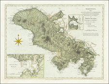
This map of the island of Martinique is detailed with various geographic features such as mountains, rivers, and settlements. The map is adorned with an ornate cartouche in the lower left corner, which includes the title and publication details. The scale of the map is provided in "Lieues." The map was published by Pierre Mariette in Paris, Rue St. Jacques à l'Esperance, with royal privilege.
Martinique was claimed for France by Pierre Belain d'Esnambuc in 1635. By 1650, it had become a French colony under the administration of the French West India Company.
On the eastern part of the island, two villages are marked, both named after prominent caciques: one near Cap Louys (Vauclin Point), where the Caribbeans gather, and another for Capitaine Pilote near Le Marin. Mount Pelee is situated on the western side of the island, close to the first French settlement of St. Pierre, where the French also constructed a fort. The residence of "Mr. du Parquet" is indicated as well; Jacques Dyel du Parquet served as the Governor of Martinique from 1636 until his death in 1658. Additionally, the map highlights the locations of several Jesuit missions. The map was engraved by Abraham Peyrounin.
![[ Charleston, Boston, New York, St. Augustine, Bahamas, etc ] Particular Draughts of some of the Principal Towns and Harbours belonging to the English French and Spanish in America and the West Indies.](https://storage.googleapis.com/raremaps/img/small/102804.jpg)
![Carta General de las Islas Antillas Menores [North sheet]](https://storage.googleapis.com/raremaps/img/small/93244.jpg)
![[Martinique, Guadaloupe, Dominica and Marie Galante] . Suite des Isles Antilles 2. Partie](https://storage.googleapis.com/raremaps/img/small/81614.jpg)