|
||

|

|
|

|
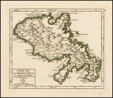
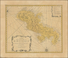
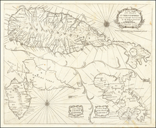
Finely engraved plan and sea chart of Martinique, first published by Guillaume De L'Isle in 1732 and here issued by Philippe Buache.
The map distinguishes itself with its meticulous detail, capturing Martinique's natural landscape with remarkable precision. The island's bays, mountains, islets, lagoons, and forests are drawn with both exactitude and aesthetic mastery. Each geographical feature is rendered with such a level of verisimilitude that the viewer can almost sense the island's lush, tropical character and diverse terrain.
Moreover, the map is not limited to the natural landscape but also includes extensive details of the human development on the island. As a flourishing colony of France during the period, Martinique was undergoing significant infrastructural and agricultural development. The map faithfully marks towns, plantation houses, windmills, watermills, and sugar works present on the island.
Furthermore, the map's indication of gun emplacements, fortifications, anchorages, and government houses reveals the military and administrative aspects of the colony. These features serve as a reminder of the strategic importance of Martinique in the colonial Caribbean and reflect the European powers' militarization of their overseas territories.
The division of Martinique into distinct "quartiers" or districts is a key aspect of the island's colonial administration and social organization. These quartiers, often marked by boundary lines and differentiated by color or shading, offer a sense of the administrative and societal structure of the island during the colonial period.The depiction of the island's parishes on the map, which are also marked by the placement of chapels, indicate the spread of Christianity across the island.
The inclusion of roads on the map offers another layer of practical detail. These vital transport links provide a sense of the island's connectivity, revealing the main routes that facilitated movement, trade, and communication across the colony. The map's indication of anchorages, small islands, and forts highlights the strategic importance of Martinique within the Caribbean's geopolitical landscape. The forts marked on the map underscore the presence of military infrastructure, a reminder of the ongoing colonial conflicts and the need for defense and surveillance during this period.
Philippe Buache (1700-1773) was one of the most famous French geographers of the eighteenth century. Buache was married to the daughter of the eminent Guillaume Delisle and worked with his father-in-law, carrying on the business after Guillaume died. Buache gained the title geographe du roi in 1729 and was elected to the Academie des Sciences in the same year. Buache was a pioneering theoretical geographer, especially as regards contour lines and watersheds. He is best known for his works such as Considérations géographiques et physiques sur les découvertes nouvelles dans la grande mer (Paris, 1754).
![Martinico [and] Dominica](https://storage.googleapis.com/raremaps/img/small/85250.jpg)