|
||

|

|
|

|
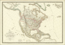
North America in the Early Years of the American Revolution
The first "Pownall" edition, the second issue of this influential wall map of North America issued shortly after the commencement of the Revolutionary War in 1777 and including the revisions compiled by Governor George Pownall.
This map is one of the most enduring wall maps of the British Colonies in North America. It was issued with corrections prior to the French and Indian War, between the wars, and during and after the American Revolution. Virtually all of the most important British and American mapmakers of the Colonial period contributed to the additions, changes, and corrections.
First issued as a separately issued map by Bowen & Gibson in 1755, this map was periodically updated following the conclusion of the French and Indian War and the American Revolution and beginning in 1775 was bound into some of the most influential American Atlases of the era, including those issued by Jefferys, Faden and Sayer & Bennett. Article IV of the 1763 Definitive Treaty is engraved in the upper right corner of the map. Articles V, VI, VII, IX, XVII and XVIII are detailed off the eastern coast of North America, while the XXth Article appears in the Atlantic Ocean.
This 1777 edition of the map is the first to have been updated to include surveys compiled by Governor George Pownall, including information from Evans and other indigenous sources. The map includes an inset of Hudson's Bay and an inset based upon Fra. Eusebio Kino's explorations to the mouth of the Colorado River.
The map is packed with Indian place names in the west, forts along the Mississippi and west of the Appalachians, and a full complement of annotations on early roads, explorations, and other geographically specific facts. The title cartouche is very decorative and features three Indian figures, mammals, a bird, and a reptile.
This is without question the best of the reasonably obtainable large-format maps of the British Colonies published in the 18th century.
Provenance
This example includes a contemporary ink inscription in the title block that credits its sale in France with Georges-Louis Le Rouge, himself a prolific mapmaker at the time. The map is backed with orange linen that was popular in France at this time.
Thus, this example stands as evidence of the cross-Channel trade in maps that occurred even during times of geopolitical tension (France would enter the American Revolution against Britain in 1778; the year after this map was produced.)
Robert Sayer (ca. 1724-1794) was a prominent London map publisher. Robert’s father was a lawyer, but his older brother married Mary Overton, the widow of prominent mapmaker Philip Overton and the proprietor of his shop after his death. Mary continued the business for roughly a year after her marriage and then, in early 1748, it passed to Robert. Robert became a freeman of the Stationers’ Company later that year; his first advertisement as an independent publisher was released in December.
Sayer benefited from Overton’s considerable stock, which included the plates of John Senex. In the 1750s, Sayer specialized in design books and topographical prints, as well as comic mezzotints. In 1753, he, along with John Roque, published a new edition of Thomas Read’s Small British Atlas, the first of several county atlases that Sayer would publish.
Sayer’s business continued to grow. In 1760 he moved further down Fleet Street to larger premises at 53 Fleet Street. In 1766, he acquired Thomas Jefferys’ stock when the latter went bankrupt. In 1774, he entered into a partnership with John Bennett, his former apprentice. The pair specialized in American atlases, based on the work of Jefferys. They also began publishing navigational charts in the 1780s and quickly became the largest supplier of British charts in the trade.
Bennett’s mental health declined, and the partnership ended in 1784. As Sayer aged, he relied on his employees Robert Laurie and James Whittle, who eventually succeeded him. He spent more and more time at his house in Richmond. In 1794, he died in Bath.
![[Important Early Geology Maps] Tableau du Climat et du Sol des Etats-Unis D'Amérique. Suivi d'éclaircissemens sur la Floride, sur la colonie Française au Scioto, sur quelques Canadiennes et sur les Sauvag . . .](https://storage.googleapis.com/raremaps/img/small/69358.jpg)