|
||

|

|
|

|
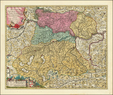
Striking map of the Duchy of Carinthia and large view of Klagenfurt, published in the first half of the 18th Century by Homann.
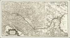
The present example includes a map of the Fortress of Preveza, Conquered by the Venetians on October 21, 1717.
This meticulously detailed 17th-century map, titled Nova et accurata Carinthiae Ducatus Tabula geographica, offers a comprehensive view of the Duchy of Carinthia, divided into its upper and lower parts, with included territories of the Archbishopric of Salzburg and several dynasties granted to the Bishopric of Bamberg, established for the Emperor Henry II around the year 1007. The map also features a striking view of Klagenfurt, the principal city of Carinthia.
During the time of Emperor Henry II, also known as Saint Henry, the regions depicted in this map underwent significant ecclesiastical and territorial changes. Henry II, ruling from 1002 to 1024, was known for his piety and his role in the strengthening of the Holy Roman Empire's ecclesiastical states, including the Bishopric of Bamberg which received various territories as donations. This map not only represents geographical divisions but also echoes the medieval ecclesiastical influence on European political boundaries.
The map divides Carinthia into its upper and lower regions, delineating major towns, rivers, and mountain ranges that define the landscape. Prominent towns such as Klagenfurt, Villach, and St. Veit are clearly marked, serving as pivotal centers during the medieval period for trade and governance. The Drau River, a significant waterway, is detailed, enhancing the map's utility for historical and geographical analysis. The inclusion of topographical features like the Carnic and Julian Alps provides insight into the natural barriers that influenced historical travel and settlement patterns.
Preveza is a coastal city in northwestern Greece.
Johann Baptist Homann (1663-1724) was a mapmaker who founded the famous Homann Heirs publishing company. He lived his entire life in Bavaria, particularly in Nuremberg. Initially, Johann trained to become a priest before converting to Protestantism and working as a notary.
In 1702, Johann founded a publishing house that specialized in engravings. The firm flourished, becoming the leading map publisher in Germany and an important entity in the European map market. In 1715, Johann was named Imperial Geographer to the Holy Roman Empire by Charles VI and made a member of the Prussian Academy of Sciences. Most importantly for his business, his reputation and contacts gained him imperial printing privileges which protected his publications and recommended him to customers. Johann is best known for this Grosser Atlas ueber die ganze Welt, or the Grand Atlas of the World, published in 1716.
After Johann died in 1724, the business passed to his son, Christoph (1703-1730). Upon Christoph’s early death, the company passed to subsequent heirs, with the name of the company changing to Homann Erben, or Homann Heirs. The firm continued in business until 1848.

![[ Transylvania ] Karte von Siebenberg nach den besten Hulfsmitteln verfast](https://storage.googleapis.com/raremaps/img/small/103015.jpg)
![[ Austria ] Arciducato d' Austria che compone parte Circulo de Medo: nome diviso . . . 1684](https://storage.googleapis.com/raremaps/img/small/60212.jpg)