


|
||

|

|
|

|
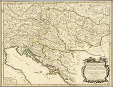
Austria Following The Siege of Vienna
Scarce Cantelli-Rossi map of Archduchy of Austria, first published by Rossi in 1684.
The map meticulously depicts the cities, rivers, lakes, mountains and Quartiers of the Archduchy. Major cties shown include Vienna, Graz, Linz, and Innsbruck (Ens).
The map is centered on the course of the Danube River from Passau to Bratislava. The Danube, a critical waterway in Central Europe, has historically played an essential role in trade, transport, and regional geopolitics. In this map, its course serves as a linear guide, illustrating the prominent settlements and territories along its banks during the late 17th century.
Starting in Passau, a significant German town known for its confluence of three rivers, the map traces the Danube as it flows southeastward, marking the progression of settlements and cities. Vienna, the capital of Austria and a dominant city of the time, would be a notable point along this journey. As the administrative and cultural center of the Archduchy, Vienna's prominence on the map is expected. Moving further downstream, the map would show the river approaching Bratislava, a city with its own historical significance, especially as a key fortress against Ottoman incursions.
The second half of the 17th century was tumultuous for Austria. A primary event of this era was the Austro-Turkish War (1663–1664), which ended with the Peace of Vasvár, a treaty that, though ostensibly a ceasefire, was perceived by many in the Habsburg dominions as a betrayal, given that large territories were ceded to the Ottoman Empire.
Later, towards the map's publication in 1684, the larger geopolitical scenario saw the commencement of the Great Turkish War (1683-1699), which would result in significant territorial changes in Central Europe. The Siege of Vienna in 1683 was a significant moment within this war, marking the culmination of the Ottoman Empire's expansion into Europe and the beginning of its decline.
Giacomo Giovanni Rossi (1627-1691) was an Italian engraver and printer. He worked in Rome, the heir to an important printing business founded by his father, Giuseppe de Rossi (1570-1639). Giuseppe began the press in 1633 and Giovanni and his brother, Giandomenico (1619-1653) took it over upon his death. The brothers expanded the business and by the mid-seventeenth century it was the best-known printing house in Rome.
For his maps, Giovanni worked with Giacomo Cantelli da Vignola. They produced the Atlas Mercurio Geografico. The first edition is undated, but the second was issued in 1692, a year after Giovanni’s death. The maps were by Cantelli. The firm also published maps based on those of Nicolas Sanson.
Later, the business passed to Lorenzo Filippo (1682-?). By 1738, the firm was known as Calcografia Camerale, then, from 1870 to 1945, as the Regia Calcografica. Today, the firm is still in business and is called Calcografia Nazionale. It operates as a free museum and offers one of the best collections of prints and plates in the world.
![[Vienna] Anno Domini 1548. Viena Austriae Hunc Habuit Situm](https://storage.googleapis.com/raremaps/img/small/86508.jpg)
![[Vienna] Prospect und Grund Riss der Kayserl Residenz-Stadt Wien . . .](https://storage.googleapis.com/raremaps/img/small/81235.jpg)
![[ Vienna ] Viennense Territorium ob res Bellicas Inter Christianos et Turcas Nuperrime Editum](https://storage.googleapis.com/raremaps/img/small/80253.jpg)