|
||

|

|
|

|
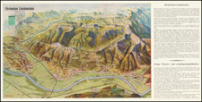
This birdseye view represents Central Switzerland and the Bernese Oberland, providing a detailed and vivid depiction of the topography and road network of this iconic alpine region.
The panoramic map that illustrates the undulating and rugged terrain of the Swiss Alps, with an emphasis on the natural beauty and geographical features that define the landscape.
The map highlights various peaks, valleys, and waterways, showcasing the diversity of the region's geography. The interlacing roads and passes, such as the Grimsel and Furka Passes, are clearly marked, indicating their routes through the mountains. These would serve as scenic paths for motor-coach excursions, as the cover suggests, offering travelers a chance to experience the majesty of the Alps. The route around Lake Thun, the Brienz Pass, and the Meiringen area are also featured, providing a guide for tourists wishing to explore these areas.
The cover, an "Excursion Map for Central Switzerland - Bernese Oberland," dates back to circa 1932 and was printed by "Verlag Erva, Reklame & Verlags AG, Zürich." It hints at the leisurely pursuits of the time, where motor-coach tours were a luxurious way to sightsee, and skilled English-speaking drivers were touted for their expertise. The cover art reflects the adventurous spirit of the early 20th-century traveler, with a stylized image of a coach winding through mountainous roads, encapsulating the allure of the Swiss landscape for visitors.
![[Rhine River Region -- Basle to Strassbourg]](https://storage.googleapis.com/raremaps/img/small/75325.jpg)
![[ Alsace - Rhine River From Basle to Spier ] Alsatiae Superioris et Inferioris Accuratissima Geographica Descriptio](https://storage.googleapis.com/raremaps/img/small/95530.jpg)