|
||

|

|
|

|
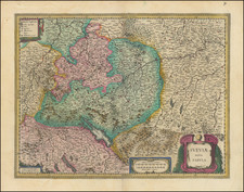
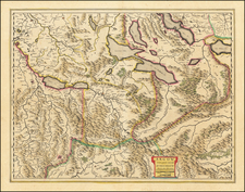
This finely executed map of Canton Appenzell offers a detailed portrayal of Appenzell and its neighboring regions. Drafted by Gabriel Walser, the map documents this eastern part of Switzerland, known for its picturesque landscapes and rich history.
he topography of the map emphasizes the distinctiveness of the Alpine mountains, particularly those belonging to the Alpstein massif. The inclusion of "Der Alpstein von Mitternacht her Anzusehen" offers a detailed perspective of several key peaks and valleys in the region. The array of mountains and high valleys, including Unter Kamor, Ober Kamor, Hohe Kasten, Soll Alp-Sigleten, Staubern, Canzel, Furglen-First Furglen, Bogarten Spiz, Marwies, Hunds-Stein, Ober vMar, Gloggern, Kray Alp, Alp Mann, Hohe Santis, Blau Schene Geirenspiz, Gletscher, Silberbaltten, and Mesmer, showcases the region’s geologic splendor.
These peaks and valleys, integral to the Alpstein mountain range, have played a crucial role in defining not just the physical landscape but also the cultural and economic activities of the region. Many of these areas have been historically significant for pasturing, and the high valleys provided crucial passages during seasonal migrations and trade.
Appenzell, being the eponymous capital of the canton, stands out prominently on the map. Historically, Appenzell has been a center for culture, administration, and trade in the region. The canton is subdivided into Appenzell Innerrhoden and Appenzell Ausserrhoden, each with its distinctive character and historical significance.
Canton Appenzell's history is marked by its early association with the Swiss Confederation. Initially a part of the Abbey of Saint Gall, the region pursued its independence and, after a series of conflicts, eventually secured its autonomy in the late 16th century. This tumultuous past has led to the division of the canton into two half-cantons: Innerrhoden (Catholic) and Ausserrhoden (Protestant).
By the time this map was crafted in 1768, Appenzell had witnessed profound socio-religious transformations, marked by the Reformation and Counter-Reformation movements. These shifts have deeply influenced the region's cultural, political, and economic trajectories.
Homann Heirs was a German publishing firm that enjoyed a major place in the European map market throughout the eighteenth century. Founded in 1702 by Johann Baptist Homann, the business passed to his son, Christoph, upon Johann’s death in 1724. Christoph died in 1730, aged only 27, and the firm was inherited by subsequent Homann heirs. This altered the name of the company, which was known as Homann Erben, or Homann heirs. The firm continued in business until 1848.
Gabriel Walser he began his theology studies in Basel in 1712, and, after study visits in Marburg, Tübingen, Jena, and Halle, he completed his examination there in 1717. He became a member of the Appenzell Synod. In 1718, he married Maria Elisabeth Zollikofer, who hailed from a noble St. Gallen family and was the daughter of Ruprecht Zollikofer. In 1721, he was elected as the pastor of Speicher, where he served from 1721 to 1745. In the land trade, he took the side of the defeated Lindens and was thus fined in 1732. In 1745, he took up the pastoral position in Berneck, which he held until his death.
In addition to his duties as a pastor, Gabriel Walser wrote the "Old and New Appenzeller Writing Calendar" for the years 1738 to 1745, a collection with easy-to-understand scientific, historical, and narrative content.
His main work was the "Neue Appenzeller-Chronick or Description of the Canton of Appenzell of the Inner and Outer Rooden", self-published in 1740. This history of the Canton since Roman times also included geographic descriptions, including a map of Appenzell. It contained an appendix with various documents from the years 1378 to 1667 and an official directory. Walser's chronicle is considered an extension and continuation of the Appenzell Chronicle of the pastor Bartholomäus Bischofberger from Trogen, which goes up to the year 1682. The more valuable, regional part of the chronicle is based on his observations. The historical part connects to Bartholomäus Bischofberger's work and supplements it up to 1732. His continuation for the years 1732 to 1772 was only published in 1829.
For the Augsburg publisher Matthaeus Seutter, Walser created maps of the cantons Lucerne, Uri, Schwyz, Glarus, and Appenzell as well as Graubünden, after numerous trips through eastern and central Switzerland. For the "Atlas Novus Reipublicae Helveticae", published in Nuremberg in 1769, he created,15 maps covering 18 cantons covering the 18 cantons of the Old Confederacy (excluding Schaffhausen) and the territories of St. Gallen, Graubünden, and Wallis, based on maps by Johann Jakob Scheuchzer, Hans Konrad Gyger, and others,from 1763 to 1768. Walser did not carry out any surveys for this. However, his maps represent a slight qualitative improvement compared to Scheuchzer's maps. In 1770, Walser's "Swiss Geography with the Sights in the Alps and High Mountains" was published in Zurich. This is an explanation of the atlas.
![(First state!) [ Bavaria, Swabia, Franconia, etc.] Suevia et Bavaria XI Nova Tabula](https://storage.googleapis.com/raremaps/img/small/96563.jpg)