|
||

|

|
|

|
Stock# 102951
Description
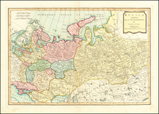
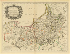
Very scarce regional map of Lithuania, Poland and the Ukraine, showing the region bounded by the Bug and Sluicz Rivers at their southern sources in the Northern Ukraine, and Konstantino, Dorogoszcz, Olyuka, Luko, Chelm, Piaski, etc. and including Southern Lithuania and Southeastern Poland.
Shows rivers, roads, towns, castles, forests, lakes and a host of other details. Quite possibly the most detailed map of this region to appear in an 18th Century Atlas.
![[ Silesia / Southwestern Poland ] Schleisien in nieder-und ober Schlesien, ndann in Furtenthumer eingethelt, nebt der Grafschafte Glatz](https://storage.googleapis.com/raremaps/img/small/102990.jpg)