|
||

|

|
|

|
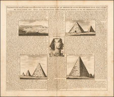
Scarce 1779 edition of Paolo Santini's highly detailed map of the region centered on the Nile, identifying place names with both ancient and modern names.
The map is based upon the work of Robert De Vaugondy and shows the main trading route from the Red Sea to the Nile, along with excellent detail in the Nile River Valley and Nile Delta. The composition is finished with an elaborate cartouche showing allegorical representations of the Pyramids, the Sphinx, and ancient Egypt.
The map was issued by the Venetian engraver Santini during a time when interest in Egypt and its history was on the rise in Italy and throughout the trend-setting centers of Europe. The fine art engraver Giovanni Battista Piranesi (1720-78) had recently done much to integrate Ancient Egyptian motifs into contemporary European Neo-Classical design. This map would have satiated the Italian public's curiosity towards this magnificent yet mysterious part of the world. The decades that followed also marked the first great era of Egyptology, during which the marvels of Ancient Egypt were scientifically studied for the first time.
Paolo Santini (1729-1793) was an Venetian engraver known especially for his religious prints and fine cartographic engravings. He published in Venice and may have a been a member of the clergy. In his maps, he largely adopted and adapted the work of his French counterparts, especially the brothers de Vaugondy.