


|
||

|

|
|

|
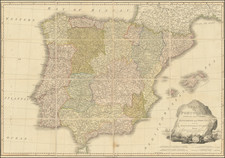
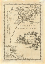
Attractive example of this engraved map of Spain and Portugal produced by William Faden, Geographer to His Majesty and to H.R.H. the Prince of Wales. Published in 1796, it illustrates the provinces and kingdoms of the Iberian Peninsula, demonstrating a remarkable fidelity to Spanish and Portuguese provincial maps.
At the time of the map's creation, the echoes of the French Revolution were being felt across Europe. The subsequent wave of Enlightenment thinking and the rise of nationalism would soon lead to the Peninsular War, forever altering the political geography of Spain and Portugal. This map captures a critical moment in time, preserving the quiet before significant historical upheaval.
A visually striking feature of the map lies in the lower right corner, where an ornate title cartouche occupies the space. Goats and grapes surround a prominent rock (Gibraltar), a reference to the agricultural richness of the region, while ships at sea highlight the Iberian Peninsula's maritime heritage.
Dominating this tableau is a woman holding a branch, positioned near a plaque bearing the inscription "HISPANIA SC". This figure, representing Hispania, personifies the Iberian Peninsula, a widespread trope of the era. The initials "SC" stand for "Senatus Consultum", pointing to the authority of the Roman Senate. The presence of Hispania and the Roman Senate's insignia together signify the lasting impact of Roman governance on the region, neatly tying the present geographical representation to its historical antecedents.
William Faden (1749-1836) was the most prominent London mapmaker and publisher of the late-eighteenth and early-nineteenth centuries. His father, William Mackfaden, was a printer who dropped the first part of his last name due to the Jacobite rising of 1745.
Apprenticed to an engraver in the Clothworkers' Company, he was made free of the Company in August of 1771. He entered into a partnership with the family of Thomas Jeffreys, a prolific and well-respected mapmaker who had recently died in 1771. This partnership lasted until 1776.
Also in 1776, Faden joined the Society of Civil Engineers, which later changed its name to the Smeatonian Society of Civil Engineers. The Smeatonians operated as an elite, yet practical, dining club and his membership led Faden to several engineering publications, including canal plans and plans of other new engineering projects.
Faden's star rose during the American Revolution, when he produced popular maps and atlases focused on the American colonies and the battles that raged within them. In 1783, just as the war ended, Faden inherited his father's estate, allowing him to fully control his business and expand it; in the same year he gained the title "Geographer in Ordinary to his Majesty."
Faden also commanded a large stock of British county maps, which made him attractive as a partner to the Ordnance Survey; he published the first Ordnance map in 1801, a map of Kent. The Admiralty also admired his work and acquired some of his plates which were re-issued as official naval charts.
Faden was renowned for his ingenuity as well as his business acumen. In 1796 he was awarded a gold medal by the Society of Arts. With his brother-in-law, the astronomer and painter John Russell, he created the first extant lunar globe.
After retiring in 1823 the lucrative business passed to James Wyld, a former apprentice. He died in Shepperton in 1826, leaving a large estate.
![(Canary Islands) Caarte Voor een gedeelte der Canarise Eylanden als Canaria, Tenerifa, Forteventura, etc. [Heightened in Gold!]](https://storage.googleapis.com/raremaps/img/small/83729.jpg)