|
||

|

|
|

|
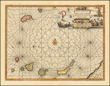
Abraham Goos's sea chart of the Canary Islands, showing magnificent detail on these African islands. The map is wonderfully laid out for seafaring navigation, with the Canary Islands strewn about the rhumb-line crossed sea. The map was originally published in Amsterdam in 1669.
The map names the islands of Fuerteventura, Palma, Tenerife, and Gros Canaria, and shows the various port cities. An inset shows the reefs and coastlines of Lancerota in greater detail. Decorative elements include a ship at sea and three developed cartouches.
An extremely decorative map of the islands.
Pieter Goos (ca. 1616-1675) was a Dutch map and chart maker, whose father, Abraham Goos (approx. 1590-1643), had already published numerous globes, land and sea maps together with Jodocus Hondius and Johannes Janssonius in Antwerp. Pieter gained recognition due to the publication of sea charts. He bought the copperplates of the famous guide book for sailors, De Lichtende Columne ofte Zeespiegel (Amsterdam 1644, 1649, 1650), from Anthonie Jacobsz. Goos published his own editions of this work in various languages, while adding his own maps. In 1666, he published his De Zee-Atlas ofte Water-Wereld, which is considered one of the best sea atlases of its time. Goos' sea charts came to dominate the Dutch market until the 1670s, when the Van Keulen family came to prominence.
![[ Vejer de la Frontera and Vélez-Málaga ] Vegel / Velis Malaga](https://storage.googleapis.com/raremaps/img/small/77661.jpg)