|
||

|

|
|

|
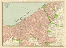
Nice example of Frank Dreher's Motorists' Handy Reference Map of Toledo, Ohio, and its vicinity from the year 1946. The map is primarily designed for automobile travelers, highlighting major roadways, landmarks, and other navigational aids that would have been essential for mid-twentieth-century motoring.
The map is detailed, with street names and important routes prominently displayed. Highways and main thoroughfares are distinguished by bold, dark lines, guiding the viewer through the city's layout. The surrounding areas and the Maumee River flowing through the region are also meticulously charted, offering a comprehensive view of Toledo and its neighboring locales.
Particularly notable is the inclusion of a grid overlay, providing a reference framework for locating specific streets or destinations. An alphabetical index of reference streets is situated in the lower right corner, ensuring user-friendly navigation. Additionally, the compass rose in the upper left corner, while rudimentary, effectively communicates the map's orientation.