|
||

|

|
|

|
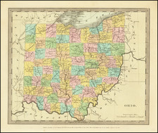
A rare antique map of the Mid-Atlantic, South and Midwest, from Rogers & Johnston's Atlas of the United States, one of the most attractive American atlases of the 19th century.
This atlas was an unusual collaboration between an American, Englishman, and Scot. The map is a fragment of Rogers & Johnston's excellent and equally rare wall map of the United States. The map names counties, towns, rivers, Indian tribes, and more.
This map and it wall map progenitor, published in 1857, are the first works in evolution of the Rogers & Johnston's collaboration, with the the wall map being issued from the 1850s until 1873 when a second example of the wall map was issued in an Atlas format, first as the People's Pictorial Atlas by J. David Williams and later as the Jones Historical Atlas, two of the rarer and more interesting late 19th century American works. An important rarity for map collectors of this region.
It portrays a collection of states with close ties that were about to be torn apart by the Civil War. Virginia and West Virginia are still united, four years before they would part ways over the issue of leaving the union. Shows small sections of surrounding states.
![[Richmond, Virginia Imprint] Map of the State of Virginia Containing The Counties, Principal Towns, Railroads, Rivers, Canals & All Other Internal Improvements. Published by West & Johnston. Richmond Va. 1862 . . .](https://storage.googleapis.com/raremaps/img/small/35235.jpg)
![[Sorority? Hazing in 1931] Cognization to the Class of 1935. . .](https://storage.googleapis.com/raremaps/img/small/81014.jpg)
![Cincinnati. From Covington [Letter from Philipp Holzmann]](https://storage.googleapis.com/raremaps/img/small/84432.jpg)
![[Pennsylvania, New Jersey, New York ] Speciel Land Charte von Pensilvanien, Neu Jersey, Neu York und von denen drey Land-schafften an dem Delaware Fl. In America in Englischer Spr. gedruckt A. 1749 In Europa duffgelegt in Teutsch Spr. zu Francfurt am M. A. 1750.](https://storage.googleapis.com/raremaps/img/small/51958.jpg)