|
||

|

|
|

|
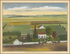
Early Sunol, California views
Finely colored example of this fine pair of early views, showing the farms and ranches of 3 of the earliest residents of the Sunol area, including pioneer Sunol residents Charles Duerr, Louis Nusbaumer and Thomas Foxwell Bachelder.
These views are almost certainly the earliest detailed views of the Sunol area. In the mid-1800s, Antonio Maria Sunol and Maria Bernal Sunol acquired 14,000 acres of land known as Rancho El Valle de San Jose. Their son, also named Antonio Maria Sunol, built several ranch buildings near what is now the Sunol Water Temple. The area grew into a larger community when former gold miners turned to farming and settled there.
The images appeared in Thompson & West's Official and Historical Atlas Map of Alameda County, California. Compiled, Drawn and Published from Personal Examinations and Surveys . . . Thompson & West's Alameda County Atlas is the definitive work of its kind for Alameda County from the 19th Century.
![[Union City] Town of Decoto, Alameda Co. Cal. / Suburban Homes in the Orange Belt](https://storage.googleapis.com/raremaps/img/small/72845.jpg)
![[Three Vintage Frank Kettlewell Cartoons]](https://storage.googleapis.com/raremaps/img/small/68562.jpg)