


|
||

|

|
|

|
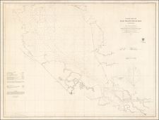
A Glimpse of the 1945 Map of Oakland Harbor by the Port Commission
The 1945 map of the Oakland Harbor, prepared by the Port Commission, offers a vivid snapshot of a vital maritime zone at a critical juncture in world history. As World War II drew to a close, naval, maritime, and industrial activities at ports around the world, including Oakland, reached unparalleled intensities. This detailed map captures the bustling activity of the harbor, showing not just the expanse of water but the intricate web of human enterprise that surrounded it.
The geographical breadth of the map is impressive, encompassing Treasure, Yerba Buena, Alameda, and Bay Farm islands. Interestingly, the map is oriented with east at the top, a departure from the conventional northward orientation most maps adopt. This shift in perspective underscores the significance of the harbor and its adjacent features, making it the focal point of the viewer's attention.
The streets, railroads, and major buildings that ribbon the harbor offer a sense of scale and connectivity. They illustrate the extensive infrastructure that supported both maritime and terrestrial operations. The addition of indexes and ancillary maps, such as the "Map showing Oakland rail & water connections" and "Map showing Oakland and San Francisco," makes this a comprehensive document suitable for both navigation and planning.
A unique feature of this map is its detailed "Index to port facilities," subdividing properties owned wholly or in part by the Port of Oakland. The index provides a window into the harbor's vibrant shipbuilding and ship repair industry. Notable yards like the Amship Corporation's Oakland and Alameda Yards, the General Engineering and Dry Dock Company, and the Moore Dry Dock Company, paint a picture of a harbor teeming with maritime activity.
U.S. Government-operated facilities hold a special place on the map, testifying to the strategic significance of the Oakland Harbor during the war years. The list includes both Army and Navy establishments, such as the Oakland Army Base, Alameda Naval Air Station, and the Coast Guard Alameda Base on Government Island. These facilities played vital roles in the logistics, training, and operation of U.S. military efforts during the Second World War.
Beyond the shipyards and military installations, the map details a plethora of other maritime activities. General cargo shipping terminals, fuel oil and gasoline facilities, and various other wharves and industries are meticulously indexed. The presence of facilities like the Eldorado Oil Company Wharf, Shell Oil Company, and Howard Terminal, among others, highlight the harbor's role in facilitating the flow of essential goods, fuels, and commodities.
No map of this era would be complete without a nod to the aviation industry. The Oakland Municipal Airport, the U.S. Navy Oakland Auxiliary Air Station, and the U.S. Navy Alameda Naval Air Station symbolize the nascent integration of sea and sky in global logistics and defense strategies.
Rarity
OCLC locates 2 examples (Bancroft Library and Harvard)
Includes the following locations:
INDEX TO PORT FACILITIES PROPERTY OWNED BY PORT OF OAKLAND
PROPERTY OWNED IN PART BY PORT OF OAKLAND
SHIPBUILDING AND SHIPREPAIR YARDS
- 49 Amship Corporation, Alameda Yard
- 20 Amship Corporation, Oakland Yard
- 51 Bethlehem-Alameda Shipyard
- 36 Cryer, William J. and Sons, Boat Yard
- 29 Curtola Company
- 41 East Bay Shipbuilding and Repair Company
- 47 General Engineering and Dry Dock Company, Alameda Yard
- 37 General Engineering and Dry Dock Company, Yard No. 3
- 38 General Engineering and Dry Dock Company, Yard No. 4
- 15 Graham Ship Repair Company, Main Yard
- 17 Graham Ship Repair Company
- 23 Hurley Marine Works 5th Avenue Yard
- 33 Hurley Marine Works Livingston Street Yard
- 10 Moore Dry Dock Company, West Yard
- 12 Moore Dry Dock Company, East Yard
- 46 Pacific Coast Engineering Company
- 27 Pacific Dry Dock and Repair Company
- 32 Parker Diesel Engineering Company
- 44 Stone, W. J. and Son, Boat Yard
- 55 United Engineering Company
U.S. GOVERNMENT OPERATED FACILITIES:
U.S. ARMY
- 54 Airforce Intransit Depot
- 2 14th Street Unit of Outer Harbor Terminal
- 4 7th Street Unit of Outer Harbor Terminal
- 1 Oakland Army Base
U.S. NAVY
- 57 Alameda Naval Air Station
- 35 Coast Guard Alameda Base, Government Island
- 16 Broadway Navy and Shipyard Ferry Landing
- 9 Ferro Street Ferry Landing
- 24 Ninth Avenue Terminal
- 43 Oakland Auxiliary Air Station
- 7 Oakland Naval Supply Depot
- 28 West Oregon Lumber Company Navy Lumber Storage
- 26 Western Terminal Company Navy Lumber Storage
- 58 Treasure Island Navy Training and Distribution Station
OTHER GOVERNMENT AGENCIES
- 33 Livingston Street Pier, War Shipping Adm.
- 56 Officers Training School, Maritime Commission
GENERAL CARGO SHIPPING TERMINALS
- 11 Eldorado Oil Company Wharf
- 13 Howard Terminal
- 14 Grove Street Terminal, Operated by Port of Oakland
- 19 Inland Waterways Terminal
- 50 Encinal Terminals
FUEL OIL AND GASOLINE FACILITIES
- 53 Associated Oil Company
- 3 Outer Harbor Terminal Oil Pier, Operated by Port of Oakland
- 39 Shell Oil Company
- 45 Signal Oil Company
- 48 Union Oil Company
MISCELLANEOUS WHARVES AND INDUSTRIES
- 5 Albera Milling Company
- 25 American Dredging Company Plant
- 31 Atlas Imperial Diesel Engine Company Wharf
- 34 Dennison Street Wharf, Port of Oakland
- 22 Fallon Street Industrial Area, Port of Oakland
- 18 Fisherman's Wharf
- 20 Hogan Lumber Company Wharf
- 40 MacDonough Steel Company
- 30 Oakland Yacht Harbor
- 52 Santa Cruz Portland Cement Company
- 21 Santa Fe Railway Company Wharf
- 6 Southern Pacific Company Oakland Pier
- 8 Western Pacific Railroad Company Pier
AIRPORTS
- 42 Oakland Municipal Airport
- 43 U.S. Navy Oakland Auxiliary Air Station
- 57 U.S. Navy Alameda Naval Air Station
![(San Francisco - Chinatown) Official Map of Chinatown in San Francisco Prepared under the supervision of the Special Committee of the Board of Supervisors July, 1885 [with:] San Francisco Municipal Reports For The Fiscal Year 1884-85, Ending June 30, 1885](https://storage.googleapis.com/raremaps/img/small/100580.jpg)
![San Francisco [June] 1849.](https://storage.googleapis.com/raremaps/img/small/97028.jpg)
![[San Mateo, California] St. Matthews Hall, Church & Rectory, San Mateo, California, Rev. A.L. Brewer, Rector](https://storage.googleapis.com/raremaps/img/small/88381.jpg)
![[ Berkeley ] The Map of Berkeley Streets & Shops](https://storage.googleapis.com/raremaps/img/small/102774.jpg)