


|
||

|

|
|

|
Stock# 101689
Description
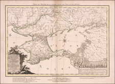
Very scarce regional map, showing area bounded by Dniester, Bruth and Moldova Rivers and including Sutzawa, Czernowitz, Sireth, Chotin, Kaminiecc Podolsky, Kyataigrod, Grodeck Mikohtschin, Hokurasza, Baja and a portion of Galitzia.
Shows rivers, roads, towns, castles, forests, lakes and a host of other details. Quite possibly the most detailed map of this region to appear in an 18th Century Atlas.
From Von Reilly's exceedingly scarce Schauplatz der fünf Theile der Welt.. Von Reilly & Schaembl led a revival of map making in Vienna in the late 18th Century which included this and several other sought after works.
![[Lithuania / Western Belarus] Partie De Lithuanie ou sont les Palatinats de Wilna et Troki, subdvises en leurs Chastellenies. et Parti du Palat.at de Minsk. . . . 1665](https://storage.googleapis.com/raremaps/img/small/76057.jpg)
![(First state!) [ Poland, Hungary, Romania, Bulgaria, Ukraine, Serbia ] Polonia Et Ungaria XV Nova Tabula](https://storage.googleapis.com/raremaps/img/small/94631.jpg)
![Europe No. 17 Partie De La Russie [Orenbourg & Petitehorde]](https://storage.googleapis.com/raremaps/img/small/19822.jpg)
![[Map of the Kiev Region] КАРТА КІЕВСКАГО НАМѢСТНИЧЕСТВА](https://storage.googleapis.com/raremaps/img/small/57871.jpg)
![(Austria) Charte der Österreichischen Monarchie, nach den letzten Friedensschlüssen berichtigt. [Map of the Austrian Monarchy, corrected according to the latest peace treaties.]](https://storage.googleapis.com/raremaps/img/small/102892.jpg)