|
||

|

|
|

|
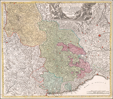
Scarce regional map of the Territory of Cremona and environs, published in Venice by Francois Santini.
Centered on Cremona and the course of the Serio River as it extends south from the Alps and the region north of the Po River, the map provide a precise and detailed depiction of the region in the latter part of the 18th Cemtury.
Cremona was first settled by the Cenomani, a Celtic tribe, around 400 BC. In 218 BC, the Romans founded Cremona as a military outpost north of the Po river, retaining its original name. Alongside Placentia (modern Piacenza), it served as a base for Roman expansion into what became Gallia Cisalpina. Cremona flourished due to its strategic location on the Via Postumia, connecting Genoa to Aquileia. Cremona supported Julius Caesar but later opposed Augustus, leading to the confiscation of its lands in 40 BC. The city was devastated in 69 AD during the Second Battle of Bedriacum, as described by Tacitus.
Rebuilt by Emperor Vespasian, Cremona resurfaced in the 6th century as a Byzantine military outpost during the Gothic War. It became a Lombard stronghold in the late 6th century but was destroyed and rebuilt several times, reflecting the turbulent political landscape of the era. From the 10th century, Cremona's bishops played significant roles in the Holy Roman Empire. The city's economy benefited from the creation of a river port, although internal discord occasionally arose. Cremona established itself as a free commune in the 12th century, often clashing with neighboring cities and the Empire. It participated in the Lombard League, which defeated Emperor Frederick Barbarossa in 1176.
In the following centuries Cremona underwent various changes in leadership, including the rule of the Visconti and the Sforza families. It faced sieges and foreign control, including Venetian and Spanish rule, each leaving a mark on the city's architecture and culture.
The early 17th century saw the region under Spanish rule as part of the larger Spanish Habsburg territories. The Treaty of Utrecht (1713) transfered control of the Territory from the Spanish to the Austrian Habsburgs.
Cremona, the central city on this map, was of notable importance during this era. Renowned for its musical heritage, particularly in violin making, Cremona was not only a cultural center but also a strategic location in terms of military and trade activities.
Unlike many of the maps in Santini's atlas, this regional map of Italy is not drawn from De Vaugondy and is based upon Italian sources.
Paolo Santini (1729-1793) was an Venetian engraver known especially for his religious prints and fine cartographic engravings. He published in Venice and may have a been a member of the clergy. In his maps, he largely adopted and adapted the work of his French counterparts, especially the brothers de Vaugondy.
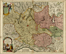
![[Toscana / Tuscany] En, candidi lectores, elegantioris Italiae partis, Tusciae scilicet, topographiam. aenis nris formis excussam in hac Tabella vobis denuo damus, atque ita quidem absolute, ut nihil amplius, in ea desiderari possit, praesertim quod, cum adiacentibus Umbriae, Aemiliae, Lombardiae, & Liguriae partibus ad unguem fuerit effigiata . . .](https://storage.googleapis.com/raremaps/img/small/75549.jpg)