|
||

|

|
|

|
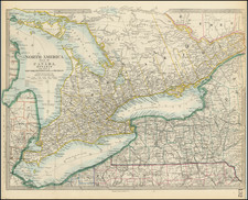
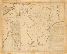
A fine example of Reid's map of Pennsylvania, the second earliest folio atlas map of Pennsylvania printed in America. The map is elegantly presented, with a clear layout of the state.
This map includes the Pennsylvanian Erie Triangle north of the 42nd parallel although evidence of an erasure of a dashed line running along the 42nd parallel suggests that the map was originally engraved by J.T. Scott (see Wheat & Brun 438). The Eerie Triangle was a disputed patch of land with claims not only from New York and Pennsylvania but also to Massachusetts and Connecticut, who believed that their "sea to shining sea" founding land grants gave them ownership of the land. Eventually, Pennsylvania bought the land from the federal government and gained access to the great lakes, which later allowed Pennsylvania to develop into an important industrial state.
Reid adapted the work of Mathew Carey for much of the content of this map. From Reid's American Atlas, the second first-ever atlas that was published in New York.
Following Mathew Carey’s publication of the American Atlas in 1795, the second large format atlas published in America was produced by John Reid of New York in 1796. The project began as an atlas to accompany William Winterbotham’s An Historical, Geographical, Commercial and Philosophical View of the United States, but was also sold separately under the title The American Atlas.
Reid’s atlas included 20 maps. In addition, John Russell’s plan of Washington, D.C. is also bound into some copies of the Atlas. Reid’s atlas was a collaborative work, with 9 of the maps engraved by Benjamin Tanner, 5 by David Martin, two by D. Anderson and one each by John Scoles and John Roberts. Two of the maps do not include engraving credits. Each of the engravers was probably working in New York (including Tanner, who had not yet relocated to Philadelphia). According to the various entries for the maps in Wheat & Brun, the cartographic content of the maps is drawn largely from Carey’s first atlas of 1795.