|
||

|

|
|

|
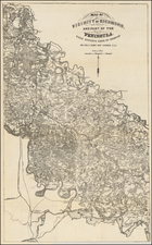
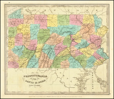
One of the Earliest Oil Maps, by the Leading American Cartographic Firm.
Fantastic map of the cradle of modern industrial civilization: the oil-producing regions of western Pennsylvania.
Of the three maps recorded by Streeter that explored the Pennsylvania oil industry in 1865, this one is considered the best general overview. Consistent with Colton's reputation as the flagship American mapmaking publisher, the map is fantastically detailed. It was surveyed by the local civil engineer H. S. Plumb, of whom we know little about save that he was active in eastern Ohio and western Pennsylvania in the late 1850s and early 1860s.
The map traces the locations of oil wells, refineries, landowners, and effectively anything else that would have been useful to an early investor or wildcatter. The main image extends from Titusville in the north to Franklin in the south, while insets show the Oil Creek and Tionesta Creek areas. Counties, towns, roads, and more are all shown, and the map is an unusually detailed regional look for Colton, who usually focused on either larger regions or individual cities for his maps.
Rumsey notes that there are, in fact, two states of the map, unrecorded by Streeter (who had the second state). The first state records substantially less development throughout, speaking to the incredibly fast-pace of growth, building, and drilling in the region. The most easily recognizable difference between the first and second states is the addition of two scale bars (including one in the esoteric unit of "roods.")
The earliest maps of the oil-producing regions of Pennsylvania come from 1864, although (perhaps with the exception of Lloyd's map) these were significantly more rudimentary than those of 1865. The other two Pennsylvanian oil maps recorded by Streeter for this year are the Hunt map and the Townsend and Dale map. Colton also produced a map of West Virginian oil-producing regions that same year.
The Early Pennsylvania Oil Industry: 1860-1865
The development of the oil industry in Pennsylvania can be traced back to the mid-19th century, marking a pivotal moment in both American industrial history and global energy production. The birth of the modern petroleum industry was at Titusville (in Crawford County, at the northwestern corner of the map), where Edwin L. Drake successfully drilled the first commercial oil well in 1859. Prior to this, oil had been collected through rudimentary methods like "seep mining," where oil seeping to the surface was simply gathered. Drake's innovation was to use a steam engine to drill a well, reaching a depth of 69.5 feet to strike oil.
The success at Titusville led to an oil boom in Pennsylvania, particularly in the regions surrounding the initial discovery. Oil Creek Valley (upriver of Titusville) became a bustling area, attracting entrepreneurs, speculators, and laborers in search of fortune. Towns like Oil City and Petroleum Center (south of Titusville) sprang up almost overnight, complete with infrastructure like pipelines and refineries. The development was so rapid that by 1861, Pennsylvania was producing millions of barrels of oil, effectively monopolizing the young industry. This period also saw the emergence of influential companies, such as the Pennsylvania Rock Oil Company and Seneca Oil, which played crucial roles in shaping the industry's future.
By 1864, the state was producing an estimated 3.7 million barrels of crude oil, a staggering amount considering the industry was in its infancy. This production was largely concentrated in the Oil Creek Valley (shown in the inset), where refineries and drilling operations had become increasingly sophisticated. The year 1865 saw the introduction of "torpedoing," a technique involving the detonation of nitroglycerin in wells to increase oil flow, further boosting production rates. This innovation was first successfully demonstrated by Colonel Edward A. L. Roberts in Titusville, revolutionizing extraction methods and setting a precedent for future drilling technologies.
The industry also began to attract significant investment and regulatory attention during these years. The Pennsylvania legislature passed the Oil Creek Railroad Bill in 1864, facilitating the transportation of oil and contributing to the infrastructure that would sustain the industry for decades to come. Financial markets started to recognize the value of oil, leading to the establishment of the Petroleum Exchange in Oil City in 1865, one of the first commodity exchanges of its kind.
Rarity
This is the only copy of the map that we trace as coming up at auction over the past decade, per RBH. In 2007, a copy of the map sold at Christie's for an astonishing $8,125.
G. W. & C. B. Colton was a prominent family firm of mapmakers who were leaders in the American map trade in the nineteenth century. Its founder, Joseph Hutchins Colton (1800-1893), was a Massachusetts native. Colton did not start in the map trade; rather, he worked in a general store from 1816 to 1829 and then as a night clerk at the United States Post Office in Hartford, Connecticut. By 1830, he was in New York City, where he set up his publishing business a year later.
The first printed item with his imprint is dated 1833, a reprint of S. Stiles & Company’s edition of David Burr’s map of the state of New York. He also printed John Disturnell’s map of New York City in 1833. Colton’s next cartographic venture was in 1835, when he acquired the rights to John Farmer’s seminal maps of Michigan and Wisconsin. Another early and important Colton work is his Topographical Map of the City and County of New York and the Adjacent Country (1836). In 1839, Colton began issuing the Western Tourist and Emigrant’s Guide, which was originally issued by J. Calvin Smith.
During this first decade, Colton did not have a resident map engraver; he relied upon copyrights purchased from other map makers, most often S. Stiles & Company, and later Stiles, Sherman & Smith. Smith was a charter member of the American Geographical and Statistical Society, as was John Disturnell. This connection would bear fruit for Colton during the early period in his career, helping him to acquire the rights to several important maps. By 1850, the Colton firm was one of the primary publishers of guidebooks and immigrant and railroad maps, known for the high-quality steel plate engravings with decorative borders and hand watercolors.
In 1846, Colton published Colton’s Map of the United States of America, British Possessions . . . his first venture into the wall map business. This work would be issued until 1884 and was the first of several successful wall maps issued by the firm, including collaborative works with D.G. Johnson. From the 1840s to 1855, the firm focused on the production of railroad maps. Later, it published a number of Civil War maps.
In 1855, Colton finally issued his first atlas, Colton’s Atlas of the World, issued in two volumes in 1855 and 1856. In 1857 the work was reduced to a single volume under the title of Colton’s General Atlas, which was published in largely the same format until 1888. It is in this work that George Woolworth (G. W.) Colton’s name appears for the first time.
Born in 1827 and lacking formal training as a mapmaker, G. W. joined his father’s business and would later help it to thrive. His brother Charles B. (C. B.) Colton would also join the firm. Beginning in 1859, the General Atlas gives credit to Johnson & Browning, a credit which disappears after 1860, when Johnson & Browning launched their own atlas venture, Johnson’s New Illustrated (Steel Plate) Family Atlas, which bears Colton’s name as the publisher in the 1860 and 1861 editions.
J.H. Colton also published a number of smaller atlases and school geographies, including his Atlas of America (1854-56), his Illustrated Cabinet Atlas (1859), Colton’s Condensed Cabinet Atlas of Descriptive Geography (1864) and Colton’s Quarto Atlas of the World (1865). From 1850 to the early 1890s, the firm also published several school atlases and pocket maps. The firm continued until the late 1890s, when it merged with a competitor and then ceased to trade under the name Colton.