|
||

|

|
|

|
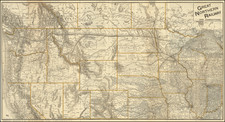
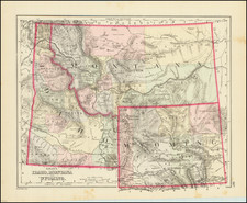
A handsome example of Mitchell Jr.'s detailed map of Wyoming, the first separately issued map of Wyoming to appear in a commercial atlas.
The map is colored by counties and shows only the 5 original territorial counties.
Shows towns, roads, rivers, lakes, railroads and proposed railroads, Indian Reservations, and a host of other details.
One of the earliest obtainable maps of the Wyoming Territory.
The map has detail in the Jackson Hole region as well as Yellowstone National Park, which is labeled and demarcated.
Samuel Augustus Mitchell Jr. inherited the Mitchell Company from his father in 1860. For over thirty years, the company had specialized in the production of school atlases and wall maps of America. They were one of the pioneers on engraving on steel plates. In 1860, Samuel Jr. released the New General Atlas, which had been compiled in house and replaced a previous atlas by Tanner. The elder Mitchell died in 1868 and Samuel Jr. continued the business until the 1890s. At its height, the Mitchell Company employed 250 people and sold 400,000 publications annually.
![(Yellowstone) [Album of 98 color lithograph post cards of Yellowstone National Park: Geysers, Buffalo, Natural Wonders]](https://storage.googleapis.com/raremaps/img/small/100920.jpg)