|
||

|

|
|

|
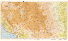
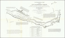
Excellent early map of Idaho Territory, Wyoming Territory and Montana Territory, published by OW Gray.
Wyoming is shown with only 7 counties. Idaho has 13 counties and Montana has only 12. Yellowstone National Park is noted as a proposed national park. Many Indian tribes are shown, along with reservations. Early railroad lines are shown, along with stations, towns, etc. Includes early forts, mountains, rivers and other details.
This is one of the best maps of the period and a series of these maps over the course of a decade tracks the fast expansion of knowledge of the region, driven by mining booms and government mapping and explorations.
O. W. Gray was a publishing firm based in Philadelphia. Later, they published as O. W. Gray & Son. They published atlases in the late nineteenth century. Gray's National Atlas was one of the most successful commercial ventures of the 1870s and one of the last to employ hand coloring on maps.
![[Montana, Wyoming, Dakota, Upper Missouri River] Amer. Sep. No. 40. Partie des Etats Unis](https://storage.googleapis.com/raremaps/img/small/93546.jpg)