|
||

|

|
|

|
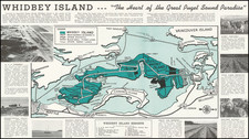
Just A Short Ferry Ride From Seattle -- Drawn by The President of the Vashon Island Auto Club
Rare early automobile road map, promoting automobile touring on Vashon Island and Maury Island, in Washington, drawn by O.S.V. (O.S. Van Olinda).
The 1916 road map of Vashon Island and Maury Island, produced by the Vashon Island Auto Club, represents a fascinating moment in the evolution of American motoring community identity. This map, detailing the roads and major landmarks of Vashon and Maury Islands in Washington State, provides a unique snapshot of the early days of automobile travel and the significance of local auto clubs in fostering the growth of this new mode of transportation.
It also notes the location of the Vashon Ferry, which would have only recently begun taking automobile traffic.
The early 20th century marked the advent of the automobile age in the United States. By 1916, the motor vehicle was transforming American society, reshaping urban and rural landscapes, and challenging traditional notions of distance and mobility. In this context, the Vashon-Maury Island road map is not merely a navigational tool but a historical document reflecting the burgeoning culture of motoring among the American public.
Auto clubs, such as the Vashon Island Auto Club, played pivotal roles during this period. They were not only social organizations but also advocates for motorists' interests, responsible for promoting road improvements, signage, and the creation of maps tailored to the needs of drivers. The emergence of these clubs was indicative of the growing importance of the automobile as a means of personal and leisure transportation.
The map itself is a detailed representation of Vashon-Maury Island's road network, highlighting the primary and secondary roads that crisscross the island. The attention to detail in the map indicates the importance of these roads to island residents and visitors alike. It features landmarks, ferry docks, and other points of interest, providing essential information for motorists navigating the island.
The road map also serves as an artifact of local history and economy. The inclusion of advertisers such as the Vashon State Bank, Marine View Inn, and Weiss Bros. General Merchandise on the map's margins reflects the intertwined relationships between local businesses and the burgeoning car culture. These businesses recognized the potential of the automobile to bring visitors and economic growth to the island, a sentiment echoed in communities across America.
The 1916 road map of Vashon-Maury Island encapsulates a transformative period in American history, characterized by the rapid growth of automobile travel and its impact on society, economy, and geography. As one of the early artifacts of this era, the map is more than a guide; it is a testament to the changing American landscape, reflecting the optimism and challenges of the early motoring age. Through its detailed depiction of roads, local landmarks, and community advertisements, the map offers valuable insights into the early 20th-century American life, the role of auto clubs, and the evolving relationship between people, their environment, and technology.
Rarity
The map is very rare.
OCLC locates 1 copy: Seattle Public Library
![[Alaska to San Diego and San Qunitin, British Columbia] A Chart Shewing Part of the Coast of N.W. America, with the Tracks of His Majesty's Sloop Discovery and Armed Tender Chatham . . . (First Modern Map of the West Coast of North America)](https://storage.googleapis.com/raremaps/img/small/102067.jpg)
![[Columbia Basin Irrigation Project] Panoramic Perspective of the Spokane Region including the Geological and Scenic Wonderland Embracing the Columbia Basin Irrigation Project and Coulee Dam . . . 1946](https://storage.googleapis.com/raremaps/img/small/77423.jpg)