|
||

|

|
|

|
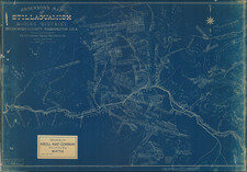
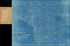
Field Used Forest Survey Map
Created and used for forestry purposes, this map showcases the rugged splendor of Colville National Forest in Washington. Much attention is payed to details like the names of rivers, heights of mountains, and boundaries of the forest. This was all done to accurately depict the Colville National Forest so authorities could balance resource use and conservation in the area.
As this map was produced for field use, it contains several observations and notes made by a forester. These observations include areas notated in color with corresponding notes in the key. Inside the key are symbols that depict ranger posts, triangulation stations used for surveying, lookout and triangulation stations, railroads, primary and secondary roads, first and second class trails, mines, springs, falls, dams, and the forest supervisor's headquarters. All this information adds to the map's utility while providing a glimpse into the development of the region since 1918.
This map is quite similar to the 1922 Colville National Forest Map. The main difference between the two is the 1922 state includes some more locations whereas this one contains manuscript annotations and possible revisions that contributed to the 1922 state.
Manuscript Annotations
The map contains annotations throughout, most prominently in the key. These notes are list-like, with the top of each section reading "Lacking," perhaps to imply the perceived absence of potentially important information. The first section seems to be symbols for the state of the forest in certain regions which can be expressed as "sparse," "abundant," and "dense."
The second section has "L-Lacking" crossed out with unsure implications. This list contains what appears to be scientific plant names, such as Ribes Cereum, Ribes Petiolare, and Ribes Cognata. These plants all appear to share a similarity in their ability to grow berries. Their significance to the overall map does not appear top be evident. There are also annotations made in colored pencil scattered around the map. These annotations range from orange circles around areas to blue outlines on rivers. Some of this blue marking extends off the page, where the author wrote "OK" and seemingly connected the two rivers. A very intriguing addition to this piece that adds to the context surrounding its usage and purpose as a map.
Colville National Forest
The landscape represented on the map began changing considerably with the arrival of the first non-Indian, David Thompson, in 1809. A fur trapper from Canada, Thompson's presence heralded an influx of trappers lured by the rich abundance of beaver, marten, and other animals. Their interactions with the indigenous tribes introduced new elements into tribal culture, including beads, tools, and alcohol.
By 1826, American fur traders established Fort Colville near Kettle Falls. These newcomers brought in livestock, started farming around the fort, and restricted native access to essential fishing grounds. By the late 19th century, indigenous tribes were confined to reservations, and the construction of the Grand Coulee Dam in the 1930s submerged Kettle Falls and its critical salmon runs under Roosevelt Reservoir.
The turn of the 20th century saw miners and homesteaders flocking to Colville, drawn by tales of wealth in its mountains and valleys. However, they met with little success. Gold and silver found around the Republic area were not as plentiful elsewhere, and the short growing season deterred farming. The population in northeast Washington declined significantly; by 1920, it was half of what it had been in 1910. Remnants of these futile endeavors are visible today in the form of abandoned mines and decaying cabins scattered throughout Colville National Forest.
However, loggers and ranchers found the landscape much more accommodating. They capitalized on the ample trees and grasslands, using the public land extensively. Initially, land use was unregulated, leading to environmental degradation. The establishment of Colville National Forest in 1906, however, marked a turning point. Forest rangers began overseeing resource harvests, curbing the rampant exploitation of resources. Despite initial friction, a workable relationship eventually evolved between the Forest Service and those utilizing the national forest lands.
The area encompassing the Colville National Forest has a rich history dating back to the mid-19th century. The Colville Indian Reservation was established in the region in 1872, following a series of treaties and executive orders. Over the next decades, waves of settlers, miners, and loggers transformed the landscape. Railroads were constructed, mines dug, roads paved, and trails blazed.
Today Colville National Forest is a popular location for recreation and conservation. The forest covers 1.1 million acres, part of which is dedicated to sustainable timber production and wildlife conservation. Colville remains a popular outdoor attraction as its rich biodiversity encourages many who visit to see wildlife, hike, camp, and do snow sports in the winter.
Colville's continued reputation as a grand national forest would not have been possible without foresters like the one who made this map. Overall, this is a great piece of early National Forest history which contains authentic notes that offers a glimpse into the past of Colville National Forest.