|
||

|

|
|

|
The Man of the Golden Spike Subdivides His Orange County Ranch
Promotional brochure, subdivision, and regional maps, and additional ephemera for Anapauma Subdivision in Orange County, developed by David Hewes, an important early California businessman.
A remarkable group of rare 19th-century Southern California promotional material, including a fine color subdivision map, for Anapauma, California, a brief yet notable real estate project in Orange County initiated by David Hewes, who achieved notoriety for providing the famous "Golden Spike" used during the ceremony marking the joining of the East and the West by rail at Promontory Summit, Utah, on May 10, 1869. Hewes commissioned San Francisco jewelers Schulz, Fischer & Mohrig to make a 5-5/8-inch-long, solid gold spike weighing just over 14 ounces, directing that they engrave on it the following words: “May God continue the unity of our Country as the Railroad unites the two great Oceans,” plus the names of Central Pacific officials and the “the last spike.”
Offered here is a collection of 4 items:
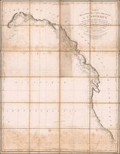
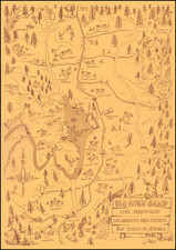
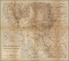
- Subdivision Map of Anapauma, Showing the Fruit Lands of David Hewes, Located in Orange County, California. Containing 820 Acres. S.H. Finley, County Surveyor. With inset Plat of Hewes Addition to El Modena. Color map. San Francisco: W.B. Walkup & Co. [1894]. On verso two additional maps and extensive text: The Counties of Southern California; Map of the Orange Belt of Southern California showing the Location of David Hewes' Fruit Ranch.
- Map and Printed form letter (from H. M. Van Arman, Los Angeles, March 7, 1894) with map on verso showing David Hewes' property, Orange County, California.
- Description of Lots in Anapauma Adjoining El Modena, Orange County, Cal. The private estate of David Hewes, which is now being sold in 5 acres, or more. Small folded brochure. 12 panels.
- Description of Lots in Anapauma. Single sheet (verso blank). Describes number of trees and type (orange, peasrs, apricots, etc.) in each lot.
Anapauma, "a place of rest," was nestled just south of El Modena, between Orange and Tustin, in the thriving heart of Orange County, which was established in 1889. The main subdivision map not only serves as an early testament to Orange County land promotion but also stands as a wonderful historical item, marking one of the final ventures of the distinguished Californian businessman David Hewes. His extensive contributions include aiding the University of California's establishment, significant land reformation in San Francisco Bay, and the iconic "Golden Spike" for the transcontinental railroad. The map delineates the parcels cultivated by Hewes in blue and those primed for cultivation in orange, with prominent Orange County roads, including Newport Avenue and Chapman Avenue, labeled. It also highlights the Tustin Branch of the Southern Pacific Railroad, potential hotel sites, and other notable features. On the reverse is a detailed promotional text extolling the development's merits. Unlike typical speculative ventures, Anapauma was partly a passion project for Hewes, who, after amassing a fortune in San Francisco, began anew on his 800-acre ranch in Tustin in 1881. This map and the accompanying literature not only chart the physical landscape but also weave the rich narrative of David Hewes, his ventures, and his lasting impact on California's cultural and physical landscapes.
Hewes' art collection of paintings, statues and frescos was presented to Stanford University. Hewes Park, which he gifted to the public, was created on an erstwhile barren hilltop in Orange, above the northwest corner of Esplanade Street and La Veta Avenue.
Rarity
These promotional maps and brochures for Anapauma are very rare in the market. OCLC notes only a single holding for these items, at Yale University.