|
||

|

|
|

|
Stock# 84988
Description
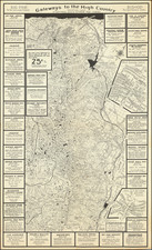
Topographical map of northeastern California, compiled by the U.S. Geological Survey in 1964 from prior surveys and the Army Map Service, in 1:250,000 scale, making it from the final regular quadrangle series.
Parts of Lassen, Modoc, Shasta, and Plumas National Forests, Lassen Volcanic National Park, the Honey Lake Valley, and the Sierra Army Depot are covered, shown in fastidious detail.
![[California, Texas, and Southwest Globe Gore] with [Strait of Anian Globe Gore]](https://storage.googleapis.com/raremaps/img/small/99425.jpg)
![[Charles Lindbergh - 1st Trans-Atlantic Flight - Printed on Linen]](https://storage.googleapis.com/raremaps/img/small/69233.jpg)