|
||

|

|
|

|
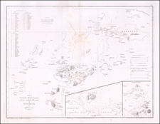
This 1863 hydrographic map titled Plano de la Silanga o Canal de la Isabela delineates the strait between Malamavi ("Isla Malamuai") and Basilan ("Isla Basalan") off the southwest tip of Mindanao in the Philippines, offers a detailed plan of La Isabela and its surroundings. Engraved by F. Bregante and M. Rodriguez, the map was created as part of the hydrographic commission of the Philippines under the auspices of the Dirección de Hidrografía in Madrid.
The map serves as a witness to the mid-19th-century Spanish imperial efforts to navigate and chart the Philippines, a strategic archipelago crucial to maritime trade and colonial administration. In the mid 19th Century, Spain was in the process of making a concerted effort to survey this region, reflecting a broader European endeavor to understand and control sea routes and land formations across the globe. The detailed rendering of La Isabela, alongside the precise bathymetric data, embodies the period's technological and scientific advancements in hydrography.
Enriched with extensive bathymetric data, it provides valuable insight into the depth and floor composition of the strait, crucial for navigation and understanding of the local maritime environment. Notations in the map, including "A" for sand, "F" for mud, "Co" for gravel, and "Cl" for coral, along with coordinates and magnetic variation readings, epitomize the scientific rigor of the era. Such detail was vital for safe navigation and reflects the broader imperial interests in the accurate mapping of territories for trade, military, and administrative purposes.
The Dirección de Hidrografía, or the Directorate of Hydrographic Works, was established in 1797. Its roots were in the Casa de Contratación, founded in 1503 in Sevilla, which housed all the charts of the Spanish Empire and oversaw the creation and maintenance of the padrón real, the official master chart. The Casa, now in Cadiz, was shuttered in 1790, but Spain still needed a hydrographic body. In response, the Dirección was created in 1797. One of its first projects was the publication of charts from the Malaspina Expedition (1789-1794). The Dirección oversaw not only publication, but also surveying. The Dirección was abolished in the early twentieth century, when their work was distributed to other organizations.
![[Philippines] Typus Freti Manilensis. Die Straet vande Manilles](https://storage.googleapis.com/raremaps/img/small/85438.jpg)