|
||

|

|
|

|
Stock# 97043
Description
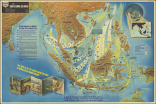
Fine large map of the Philippine Islands, published to provide information during World War II.
Newsmap was a production of the Special Service Division Army Service Forces, War Department.
Color map on one side, two color maps and text on verso. Light wear to corners of folded map resulting in some separation starting at fold intersections, couple of small pinholes in borders. The map is very crisp and clean, hardly ever opened. On one side is a very large aerial physical map of the Philippine Islands (scale approximately 4 1/2 inches to 100 miles) with roads and rivers marked.
Condition Description
Minor loss at top left and right corners.
![[ Early Industrial Philippine Logging ] Negros Philippine Lumber Co. & Insular Lumber Co. [with] The Passport of James H. Ramey](https://storage.googleapis.com/raremaps/img/small/77143.jpg)
![[Manila - Luzon] Typus Freti Manilensis. Die Straet vande Manilles](https://storage.googleapis.com/raremaps/img/small/61346op.jpg)