|
||

|

|
|

|
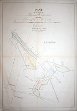
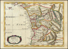
The First Geological Map of Tigray and Central Eritrea
Rare geological map of the central part of Eritrea and the Tigray region of northern Ethiopia, published in conjunction with the geological surveys by Ferret and Galiner between 1839 and 1843.
The expedition by Pierre Victor Adolphe Ferret and Joseph Germain Galinier to Abyssinia, was commissioned by the French government, to expand the understanding of the northern territories of the Ethiopian Empire, an area of strategic interest to European powers of the time. Setting out in 1839, Ferret and Galinier traversed the highlands of Abyssinia, focusing their efforts on the provinces of Tigré, the historical region of Samen (now part of the Amhara Region), and Amhara itself.
Beginning in Massawa, a port city on the Red Sea, the pair ventured into the interior, traveling through regions that would later become pivotal in the formation of modern Ethiopia. They visited notable cities and regions such as Adwa, Axum—home to ancient obelisks and a center of early Ethiopian civilization—and the fabled court of Gondar, once the seat of the Abyssinian emperors.
Throughout their travels, Ferret and Galinier meticulously recorded observations on the local geography, including mountain ranges like the Simien Mountains, rivers such as the Tekezé, and significant lakes. They took note of the agricultural practices, trade activities, religious institutions, including the Ethiopian Orthodox Church, and social customs of the Amhara, Tigrayans, and other ethnic groups they encountered.
The French government's aim in commissioning this expedition was multifaceted, encompassing a desire for diplomatic relations, trade opportunities, and scholarly curiosity about the source of the Nile. The subsequent comprehensive reports and illustrations produced by Ferret and Galinier upon their return provided an unprecedented level of detail about the Ethiopian highlands and contributed significantly to the cartographic and ethnographic knowledge of the region during a period when Africa was still largely mysterious to European powers. Their work offered a foundation for future diplomatic and missionary ventures and opened a window to the rich heritage and natural beauty of Abyssinia.
The map was likely prepared to accompany Ferret and Galinier's Description geologique du Tigre et du Samen Voyage en Abyssinie.
Provenance: Includes two stamps from "Archive Ministere Des Affaires Etrangeres - Service Geographique." The handwritten notes are likely from a Prussian Military archive. The archives