|
||

|

|
|

|
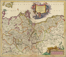
Striking and decorative example of Seutter's map of the Baltic region, including Samogitiae, Curalndia, Semigallia, Polonica, Livonia, Lithlandia, Estonia, Olden, Kikelandia, Wikkelandia, Harnlandia, Wirnaldia, Irvenlandia, etc. Extremely detailed, showing towns, rivers, mountains, lakes, forests, etc. Strking cartouche and smaller cartouche w/scale of miles. This copy is trimmed to the neatline and laid on contemporary paper, as was the style of the 18th Century when maps were rebound into composite atlases.
Matthäus Seutter (1678-1757) was a prominent German mapmaker in the mid-eighteenth century. Initially apprenticed to a brewer, he trained as an engraver under Johann Baptist Homann in Nuremburg before setting up shop in his native Augsburg. In 1727 he was granted the title Imperial Geographer. His most famous work is Atlas Novus Sive Tabulae Geographicae, published in two volumes ca. 1730, although the majority of his maps are based on earlier work by other cartographers like the Homanns, Delisles, and de Fer.
Alternative spellings: Matthias Seutter, Mathaus Seutter, Matthaeus Seutter, Mattheus Seutter
![[Soviet Union] Our Country -- From Wooden Plough To Sputnick](https://storage.googleapis.com/raremaps/img/small/47092.jpg)