|
||

|

|
|

|
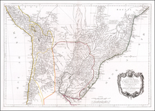
Rare separately issued chart of the entrance to the Rio Grande de San Pedro in Brazil, based upon a manuscript chart drawn by Pedro d Elola, drawn during the Spanish-Portugese War in early 1777.
Includes a note with sailing directions, soundings, shoals, place names, compass rose and other details.
The map was prepared by Tomas Lopez from original manuscript maps and information drawn from the expedition of Pedro Rodriguez Cevallos (November 1776 to August 1777), which Lopez had obtained through Pedro Rodriguez Campomanes, the director of the Real Academia de la Historia (Madrid), which retained the original manuscripts. In turn, Lopez presented 2 copies of his newly printed map to the Academia on October 3, 1777.
Tomás López de Vargas Machuca (1730-1802) was one of Spain’s most prominent cartographers in the eighteenth century. He was born in Toledo but studied at the Colegio Imperial in Madrid, where he focused on mathematics, grammar, and rhetoric. Along with a small group of colleagues, in 1752 the Spanish government sent López for training in Paris with the renowned geographer Jean Baptiste Bourguignon d’Anville. When he returned to Spain he was named Geógrafo de los dominios de Su Magestad and put in charge of the geographic collections of Charles III. He published many maps, including his fascinating maps of the Americas, and a variety of geography manuals. Some of his most famous maps are of the Iberian Peninsula, part of his large project to create a majestic atlas of Spain. Unfinished in his lifetime, López's children published the Atlas Geográfico de España (Geographical Atlas of Spain) in 1804. It was republished in 1810 and 1830.

![A collection of five watercolor drawings from the Luso-Hispanic Border Commission in the Amazon Basin, drawn by its Spanish commanding officer: Parte del camino de tierra de Quito al R. Napo (Lamina I); Vista de la Poblacion y Fortaleza de S. Fran[is]co Xavier de Tabatinga (Lamina V); Vista del Salto grande del Rio Yapurà desde la dist.a de 3 Leguas (Lamina X); Vista del Grande Salto inaccesible del Rio Yapurá (Lamina XI); Los Pongos del Rio Marañon [Lamina XVIII].](https://storage.googleapis.com/raremaps/img/small/100698.jpg)

![[Bahia de Todos Santos] t'Neemen van de Suyker Prysen in de Bay de Tode los Santos Anno 1627](https://storage.googleapis.com/raremaps/img/small/75293.jpg)