|
||

|

|
|

|
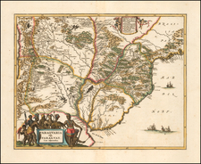
Pocket Map of Brazil
Rare 1681 map of Brazil done by Johann Hoffman modeled after a similar map by Pierre Du Val. The map, produced for Hoffman's pocket atlas, depicts Brazil's coast and parts of the interior.
The map features a simplified Amazon River in the top left along with other rivers, forests, and settlements like San Salvador. The coast and nearby inland regions are fairly detailed, with many different locations depicted. The subsequent map in the atlas shows the southern coast of the continent which provides a nice depiction of the South America charted by Europeans.
Above the map's cartouche is a depiction of northern Uruguay and a portion of the Guiana region. Notably, this illustration shows the mythical Lake Parima, believed to be the site of El Dorado. A popular element in maps of this era, this fictional lake underscores the map's unique qualities and reflects the European exploratory push into South America, driven by the quest for El Dorado. The myth of Lake Parima persisted until its disproval in the 19th century.
Pierre Duval (1618-1683) was a French geographer, cartographer, and publisher who worked in Abbeville and Paris during the seventeenth century. He was born in the former city, in northeast France, before moving to Paris. Duval was the nephew of the famous cartographer Nicolas Sanson, from whom he learned the mapmaker's art and skills. Both men worked at the royal court, having followed the royal request for artists to relocate to Paris. In addition to numerous maps and atlases, Du Val's opus also includes geography texts. He held the title of geographe ordinaire du roi from 1650 and died in 1683, when his wife and daughters took over his business.
![Suite Du Bresil . . . [2 maps]](https://storage.googleapis.com/raremaps/img/small/103662.jpg)
![[Ilha da Santa Catarina to Bombinhas]](https://storage.googleapis.com/raremaps/img/small/59595.jpg)