|
||

|

|
|

|
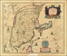
Nice old color example of Blaeu's map of China, from the Atlas Sinensis.
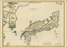
A important general map of China, Korea and Japan, published by Joan Blaeu in the Jesuit Martino Martini's Atlas Sinensis , the first western atlas of China.
The map Incorporates the discoveries of Joao de Goma and de Vries into this map. Korea is no longer depicted as an island. Blaeu's map is also the first map to name and show Hokkaido (Ezo) as an island to the north of Honshu. China is mapped with considerable accuracy for the period: the Great Wall is shown.
Martini was the Jesuit Superior in Hangchow, giving him access to indigenous and Jesuit surveys of all the regions of China which he brought back to Europe in 1654 for printing and publication.
Joan, or Johannes, Blaeu (1596-1673) was the son of Willem Janszoon Blaeu. He inherited his father’s meticulous and striking mapmaking style and continued the Blaeu workshop until it burned in 1672. Initially, Joan trained as a lawyer, but he decided to join his father’s business rather than practice.
After his father’s death in 1638, Joan and his brother, Cornelis, took over their father’s shop and Joan took on his work as hydrographer to the Dutch East India Company. Joan brought out many important works, including Nova et Accuratissima Terrarum Orbis Tabula, a world map to commemorate the Peace of Westphalia which brought news of Abel Tasman’s voyages in the Pacific to the attention of Europe. This map was used as a template for the world map set in the floor of the Amsterdam Town Hall, the Groote Burger-Zaal, in 1655.
Joan also modified and greatly expanded his father’s Atlas novus, first published in 1635. All the while, Joan was honing his own atlas. He published the Atlas maior between 1662 and 1672. It is one of the most sought-after atlases by collectors and institutions today due to the attention to the detail, quality, and beauty of the maps. He is also known for his town plans and wall maps of the continents. Joan’s productivity slammed to a halt in 1672, when a fire completely destroyed his workshop and stock. Joan died a year later and is buried in the Westerkerk in Amsterdam.
![[ Japan and East Coast of Korea ] Charte Der Iapanischen Inseln . . . 1811](https://storage.googleapis.com/raremaps/img/small/97099.jpg)

![Zhuili (Dili) Tu [Geographical Map (of China)] 墬理圖](https://storage.googleapis.com/raremaps/img/small/65048kb.jpg)