|
||

|

|
|

|
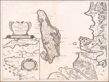
Extremely Rare Hondius Hague Imprint Map of the English Landing at Ile de Re.
Fine old color example of this extremely rare map of Poitou-Charentes with Île de Ré and the French coast with La Rochelle, oriented to the Northwest, with two inset fortification plans: Fort de la Pree and Fort de St Martin, published in 1627 by Melchior Tavernier.
The map shows the Fortifications of Fort de la Pree and Fort St. Martin, along with the topographical features, and fortifications of various other places on Isle de Re and the contiguous French Coastline, during the battle between the English and French in the region. In the eastern part of the island, the areas where the British have landed are shown, with the locations of the King's armies. The blockade of Saint-Martin is also shown.
Published in The Hague by Henricus Hondius, a very rare imprint for Hondius, who was primarily working from Amsterdam.
In the early 17th century, the region illustrated in this map was a focal point of military and naval activity, particularly during the religious and political conflicts that characterized France. The map's emphasis on fortifications and strategic locations such as La Rochelle and the Île de Ré sheds light on the intense struggles for control between Catholic and Protestant forces, notably during the Siege of La Rochelle (1627-1628). The detailed depiction of fleets, especially at the "Rade de Lobye," provides a visual narrative of the significant maritime engagements, a testament to the area's strategic maritime importance.
The inclusion of insets "Plan du fort de st. Martin" and "Plan du fort de la Pree" in the lower left corner enhances the map's coverage of local military landmarks. These detailed plans offer an intimate look at specific fortifications, crucial for understanding the era's military architecture and defensive strategies.
In 1627, the English embarked on a significant military expedition against France by landing on the Île de Ré, a strategic island near the coast of La Rochelle. This operation, led by the Duke of Buckingham, George Villiers, was part of the larger Anglo-French conflict of the time, influenced by the broader turmoil of the Thirty Years' War in Europe. The English aimed to support the Huguenot rebels in La Rochelle, a Protestant stronghold, against the Catholic French monarchy. However, despite the initial success in landing and establishing a foothold on the Île de Ré, the English forces soon faced logistical challenges and stiff resistance from the French defenders. The siege that ensued marked a significant military engagement of the period, highlighting the complexities and religious dimensions of the early 17th-century European conflicts. The English eventually suffered a costly defeat, with heavy losses and failed objectives, underscoring the difficulty of projecting power across the Channel in that era.
Rarity
The map is extremely rare. We find catalog entries at the Royal Danish Library, BnF, and BNE.
This map was issued in the same year and style as Melchior Tavernier's important map of the same region.
Henricus Hondius (1597-1651) was a Dutch engraver and mapmaker, a member of a prominent cartographic family. His father, Jodocus Hondius, was also an engraver and geographer. While working with his father, Henricus was instrumental in the expansion and republishing of Mercator’s atlas, first published in 1595 and republished by Hondius in 1606.
Upon his father’s death in 1612, Henricus and his brother, Jodocus the Younger, took over the business. He set up his own shop in 1621, where he continued to release new editions of the Mercator atlas. Later, he partnered with his brother-in-law, Jan Janssonius, in continuing to expand and publish Mercator’s atlas, which would become known as the Mercator-Hondius-Janssonius atlas. Born and based in Amsterdam, he died there in 1651.
![[Siege of Poitiers] Vero disegno della nobilissima Citta di Poitiers, nella Gallia Celtica, Soggi Aquitania detta, e, da Ceare Pictones Populi. Con il tremendo assedio de essa, postolio alli xxvij, di Luglio di questo anno M.D. Lxix da GAsparo Coligni S. di Ciatiglion gia Armiraglio di Francia dal Prencipe di Navarra et di Conde, et altri SS. Cavalieri Francesi Vasalli del Re et Capi della setta Ugonotta. con altri d’Alamagna condotti dal Conte di Mansfelt. et tenuto sino alli vy di Settembre. . . .](https://storage.googleapis.com/raremaps/img/small/61361sb.jpg)