- Antique Maps
- Asiae Recentissima Delineatio…
This item has been sold, but you can enter your email address to be notified if another example becomes available.
Map Maker
Title
Asiae Recentissima Delineatio…
Publication Place / Date
Nuremberg / 1720
Image Dimensions
22.5 x 19 inches
Color
Hand Colored
Condition
VG
Stock# t0099
SOLD
Map Maker
Authenticity Guarantee
All of our maps are authentic antique maps, printed or drawn on or about the date shown in the description. In rare instances when we offer facsimiles, we will specifically describe the map as a later facsimile and include the date of publication. Certificates of Authenticity are included with each item.
Map Maker
Fast, Global Shipping
Last year we shipped over 4,500 antique maps to more than 50 countries. Maps are shipped Monday through Friday year-round. If an order is received before 2 PM PST, we will ship the order that day. If an order is received after that time, we will ship the next day. We ship maps either flat in custom packages or in specially ordered thick tubes. Shipping rates are provided as part of the checkout process.
Description
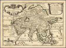
Striking map of Asia and the Northern parts of Australia, by JC Homann, one of the earliest of the Homann Heirs. The map shows Comagnie Land as a partial unknown island above Japan and Kamchatka. It also shows the straits between New Guinea and Australia in a quite tentative fashion, noting Dampier's Strait and a disembodied Carpenteria with no definite northern limit. Rich full color cartouche. Narrow left and right margins, but sufficient for framing.
Related Categories
Related Items