|
||

|

|
|

|
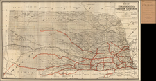
One of the best early surveys of Kansas and Nebraska. Only the eastern portions have been subdivided into counites and townships, with the west substantially wide open. Includes the location of Land Grant Railroads, and the 20 and 25 miles limits of same, along with land offices and the surveyor general's office. Areas with Coal, Salt, Lead, Platina and Marble are noted with color coding. Wheat notes that the Butterfield Overland Despatch Route goes out to Smokey Hill in Kansas, but the most interesting feature is the railroad information. The Union Pacific gives the impression of having been built to the forks of the Platte, 3rd 100 miles, which was not true as of August 25, 1866, when the map was signed, but was true by the end of December 1866. Farther south, the Kansas Pacific Rout is shown connecting Manhattan, Leavenworth, Kansas City and Lawrence. Minor fold spits and small loss at the fold intersections. The map is mounted on linen, as issued. A nice example of this map, which has not appeared in a dealer catalogue since 1983 (Arkway, Catalogue XXI).
![[ The Old Northwest Territory ] Il Paese De Selvaggi Outagamiani, Mascoutensi Illinesi E parte Delle VI Naxioni](https://storage.googleapis.com/raremaps/img/small/75927.jpg)