
This item has been sold, but you can enter your email address to be notified if another example becomes available.


|
||

|

|
|

|
Stock# m0278
Description
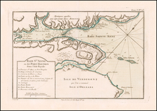
The first map of the Siege of Quebec. Gives detailed operations of the siege and shows key battle sites and encampments. An inset shows the Plan of the Action gained by the English near Quebec, Sep. 13, 1759. The various groups of war ships are shown in and around the harbor, including Admiral Holmes Division, Admiral Saunders Division and others. On the ground, General Wolfe's Camp, Major Hardy's Post, the French Encampment, Brig. General Moncton's Camp and others are shown. A highly detailed an informative plan of one of the most important French & Indian War engagments. Jolly Lond-178.
![[ British Colonies in North America ] Carte Nouvelle de L'Amerique Angloise contenant tout ce que les Anglois possedent sur le Continent de L'Amerique Septentrionale . . .](https://storage.googleapis.com/raremaps/img/small/100143.jpg)
![[Unique Extra-Illustrated Example!] Carte Nouvelle Contenant La Partie d'Amerique La Plus Septentrionale, . . . Le Canada ou Nouvelle France, La Nouvelle Ecosse, La Nouvelle Angleterre, Les Nouveau Pais Bas, La Pensylvanie . . . Et Jle. de Terre Neuve . . .](https://storage.googleapis.com/raremaps/img/small/47720.jpg)

![A Map of Lewis and Clark's Track Across the Western Portion of North America, from the Mississippi to the Pacific Ocean. By Order of the Executive of the United States in 1804, 5 & 6. . . . [Complete with 3 volumes of Text: Travels to the Source of the Missouri River and Across the American Continent to the Pacific Ocean. Performed by Order of the Government of the United States, in the Years 1804, 1805, and 1806].](https://storage.googleapis.com/raremaps/img/small/81775.jpg)