This item has been sold, but you can enter your email address to be notified if another example becomes available.


|
||

|

|
|

|
Stock# m0249
Description
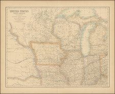
Rare early map of Wisconsin and Iowa from Greenleaf's scarce New Universal Atlas. This maps stretches from the Great Lakes across the Plains with little detail outside of southern Wisconsin and Eastern Iowa where a few counties are separated by color. In southern Wisconsin travel routes, towns, and railroads are shown. Many rivers and streams are shown and named on the map. Indian areas such as the Iowas, the New York Indians, Chippeways, etc. are marked as is Carvers Tract. This area of land was granted to Jonathan Carver and his heirs by the Sioux Indians. Karrow 6-1656.