|
||

|

|
|

|
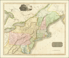
Wonderful example of Massachusetts and Rhode Island from Tanner's New Universal Atlas.
This map is hand colored by county and contains great detail. Topograpy, cities, waterways, travel routes, and rail lines are all shown on the map. A statistical inset provides population by county. Large inset map shows a detailed plan of Boston with references to the major points of interest. Minor foxing in the right margin, otherwise a very good example. anner's New Universal Atlas became the standard work in the Industry until Tanner sold the rights to the atlas in 1846 to SA Mitchell. The early editions, engraved by J. Knight, are well regarded for the high quality paper and fine engraving, comparable to the American Atlas. Tanner's Universal Atlas is now rare on the market and the separate maps are now increasingly difficult to obtain.
![(Coast of Florida, Georgia and the Carolinas] [To The Members Of The Nautical Institution And Ship-Masters' Society Of The City Of New York, This Chart, Extending From Lat. 40°15 N., Long. 72°15 W., to Lat. 22°35 N., Long. 80°25 W., Is Respectfully Dedicated / By Their Obedient Servant Edmund M. Blunt]](https://storage.googleapis.com/raremaps/img/small/77294.jpg)