|
||

|

|
|

|
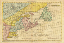
Rare map of the State of Vermont by James Whitelaw. Whitelaw was a Scotish Surveyor, who came to America in 1773 as an agent for the Scots-American Company of Farmers. Whitelaw and David Allen purchased the southern half of the New Hampshire Grants town of Ryegate and established a Scottish Colony of settlers in 1774. The settlement was part of the influx of settlers in the Connecticut Valley, following the conclusion of the French & Indian War. Whitelaw first came to cartographic prominence during at the beginning of the Revolutionary War, when General Washington was seeking the shortest route from Boston to Canada, which resulted in the military road from Newbury to St. Johns also known as Hazen's Road. After the route was located in March 1776, James Whitelaw was retained to conduct the survey of the road, which became his first notable contribution to American Cartography. In 1783, he became the Deputy Surveyor of the State of Vermont and 4 years later succeeded Ira Allen as Surveyor General. In the next 17 years, Whitelaw conducted an systematic conversion of indigenous information into a fine set of maps of the state. This map, which is clearly based upon his wall map of 1796, provides a remarkably detailed look at Vermont, including towns, townships, counties, rivers, roads, lakes, mountains and a host of other details. While the map is illustrated in Graffagnino (p80), its source is curiously absent and we could find no reference to the map in Phillips or otherwise.