


|
||

|

|
|

|
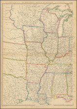
Rare map which apparently precedes the Michigan Territory map by Lucas. The earlier version shows Michigan Territory as including the Northwest Territory. This example shows a demarcation between the two. Rivers, mountains, Indian borders shown. Michigan extends into part of present day Wisconsin while the Northwest Territory is comprised of part of present day Minnesota and Wisconsin. Sources of the Mississippi 3038 miles above the Gulph of Mexico are noted as are numerous Indian villages. Striking example of Fielding Lucas' fine work, which distinguished him as the best publisher of the era. Lucas' maps are highly desireable and increasingly scarce. His maps are printed on a higher quality paper than contemporary maps by Carey & Lea and demonstrate a superior engraving quality and more attractive coloring style. A fine example of this map, issued by one of the most important early American publishers, which are now virtually unobtainable in atlas form and rarely appear on the market in individual maps.
Fielding Lucas, Jr. (1781-1854) was a prominent American cartographer, engraver, artist, and public figure during the first half of the 19th century.
Lucas was born in Fredericksburg, Virginia and moved to Philadelphia as a teenager, before settling in Baltimore. There he launched a successful cartographic career. Lucas's first atlas was announced in early- to mid-1812, with production taking place between September 1812 and December of 1813, by which point the engravings were complete. Bound copies of the atlas -- A new and elegant general atlas: Containing maps of each of the United States -- were available early in the next year, beating Carey to market by about two months. Lucas later published A General Atlas Containing Distinct Maps Of all the known Countries in the World in the early 1820s.

![[The First Maps Printed Color] Cartes en Couleur des Lieux Sujets aux tremblements de Terre Dans toutes les parties du Monde Selon le Sisteme de l’impulsion Solaire](https://storage.googleapis.com/raremaps/img/small/52293op.jpg)

