|
||

|

|
|

|
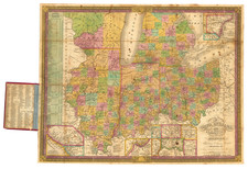
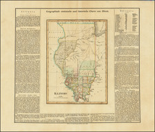
Flawless example of the first edition of Tanner's map of Illinois, with interesting early/primitive counties, Indian Lands, etc. Chicago is now part of Illinois and Ft. Dearborn appears. Cook, La Salle and Joe Davis Counties are very large, as are a number of other yet to be divided counties. Many early roads, rail lines (existing and proposed) and canals appear. Tables show the distances along the various steam and stage routes. A large inset of the Lead Region in Huron District (Wisconsin) is shown, essentially covering the wedge between the Wisconsin and Mississippi Rivers, a region which was then heavily populated with early mining camps and settlements. The Smelting Furnaces, Minearl and Ore Lands, Farms and Mills are shown in the inset. Tanner's New Universal Atlas became the standard work in the Industry until Tanner sold the rights to the atlas in 1846 to SA Mitchell. The early editions, engraved by J. Knight, are well regarded for the high quality paper and fine engraving, comparable to the American Atlas. Tanner's Universal Atlas is now rare on the market and the separate maps are now increasingly difficult to obtain.