


|
||

|

|
|

|
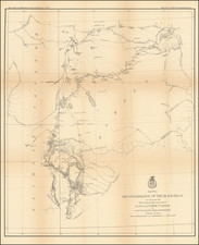
An early rare map showing the Midwest and Upper Plains from Morse's American Geography. The map was engraved by Samuel Hill, whose rare plan of Washington is one of the most highly sought after of all early American Engravings. The map represents the first attempt to issue a separate atlas map of the Old Northwest, extending from the (conjectural) sources of the Mississippi and Missouri Rivers in the west to Lake Erie and the Connecticut Lands in the east, centered on the Mississippi Valley and extending south to the confluence of the Ohio River and New Madrid. North of the Ohio, Washington Co., the Virginia Lands, Connecticut Lands, and Indian Line from the Treaty of Grenville appear. Many early forts appear, including Fort Knox, Post Vincennes Fort Detroit, Fort Joseph, Fort Defiance (with a battle note), Ft. Jefferson, Ft. St. Clair, Ft. Hamilton, Ft. Stuben, Ft. Recovery, Ft Washington, and others. The Ohio Company Lands are also shown, as are the 7 Ranges. In the west, the pre-Lewis & Clark knowledge of the Missouri is evident, with a note that the River is navigable for 1300 miles. Many Indian Villages and important portages are shown. A high plain is shown in the Michigan Peninsula. The fictitious Bellin-Charlevoix islands in Lake Superior are present. A scarce map, which rarely appears on the market. Wheat & Brun 679
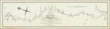


![(Civil War) Fredericksburg … [with] Map… of the Sioux Expedition [with] Map of the Fight of the 14th A.C. Buzzard Roost, GA [and ] Big Mound [and] Dead Buffalo Lake [and] Dry Fort Creek](https://storage.googleapis.com/raremaps/img/small/97072.jpg)