The item illustrated and described below is sold, but we
have another example in stock. To view the example which
is currently being offered for sale, click the
"View Details" button below.


|
||

|

|
|

|
Stock# m0019
Description
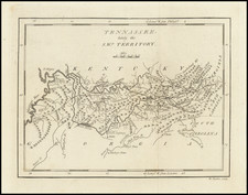
Nice example of Mathew Carey's map of Tennessee from Carey's American Pocket Atlas, the third separately issued map of Tennessee to appear in a commercial atlas.
The northeastern corner of Tennessee is too far east. The Yaszoo River and Tombigbee River are identified. Includes nice topographical detail, plus forts, roads, towns, mountains, rivers, Muscle Shoals and other early details.
States of the Map
There are 3 known states of the map:
- State 1 (1796): No roads.
- State 2 (1801): In the upper border, a line has been added through the numerals for 10 degrees Longitude. Roads have been added.
- State 3: (1805): New place names include Port Royal, Palmyra, Jefferson, Franckfort, Craigfort, Kingston, Greenville and others. A number of new roads are also added.
An essential map for Tennessee Collectors.