|
||

|

|
|

|
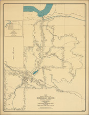
This 1985 topographical poster map, detailing the Napa Valley vineyards, serves as an emblematic representation of the region's viticultural prominence. Prepared by Carto Graphics in San Francisco with lithography by Mastercraft Press, it was commissioned by the Napa Valley Vintners Association and the Napa Valley Grape Growers under the auspices of the Napa Valley Appellation Education Committee. The map delineates various vineyard types, including winery-controlled, independent grower vineyards, and those outside the official Viticultural Area, marked with distinct symbols and color codes to indicate acreage sizes.
The historical context of this map is deeply rooted in the evolution of Napa Valley as a significant wine-producing region. By 1985, Napa Valley had firmly established itself on the global wine map, owing to its unique climate and geology favorable for diverse grape varieties. The map's detailed listing of principal grape varieties, including Chardonnay, Cabernet Sauvignon, and others, along with their respective acreages, reflects the region's agricultural diversity and the growing sophistication of its wine industry. This era marked a significant turning point, with Napa Valley wines beginning to rival those of established European vineyards.
Cartographically, the map is notable for its precise representation of geographical and viticultural details. The inclusion of landmarks like Chateau Bouchaine in the south and Aetna Springs in the north provides a clear spatial orientation. The use of colors—green, a grape-like purple, and grape-like red—enhances the visual appeal and aids in distinguishing different areas and features. The map's scale, specifically tailored to vineyard sizes, underscores its utility as a tool for understanding the expansive and varied terrain of Napa Valley's wine-growing regions.
![[ First Printed Map of San Francisco Bay ] Plan Du Port De St. Francois Situe sur la cote de la Californie . . .](https://storage.googleapis.com/raremaps/img/small/90983.jpg)