|
||

|

|
|

|
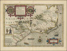
One of the most highly sought after of all maps of Georgia is this 1748 map of Georgia, Florida, the Carolinas and Louisiana, from John Harris' Navigantium atque Itinerantium Bibliotheca, or Complete Collection of Voyages and Travels, first published in London in 1705. The map of Georgia first appeared in the 1744-48 and 1764 editions, when a new Chapter was added, giving a history of Georgia. The map covers the region from Charleston to the Mississippi River. Cumming notes that it is one of the best large format maps of the region during the period, showing coastal settlements in South Carolina, the Indian Tribes friendly or hostile to the English, and the chief trading paths of the period. Indian territories are shown by fine dotted lines. The Georgia roads and settlements are particularly complete. Excellent detail along the Flint River. An excellent example of this highly sought after map, with wide margins and the ususual minor offsetting. Cumming 267; Hodler & Schretter, The Atlas of Georgia.
Emanuel Bowen (1694?-1767) was a British engraver and print seller. He was most well-known for his atlases and county maps. Although he died in poverty, he was widely acknowledged for his expertise and was appointed as mapmaker to both George II of England and Louis XV of France. His business was carried on by his son, Thomas Bowen. He also trained many apprentices, two of whom became prominent mapmakers, Thomas Kitchin and Thomas Jeffreys.
![[ Method by which native Floridians discuss matters of grave importance ] Qua ratione Floridenses de seriis rebus deliberant. XXIX.](https://storage.googleapis.com/raremaps/img/small/97363.jpg)
![[British Colonies in America] Carte Qui Contient Une Description Des Iles & Terres Que Les Anglois . . .[maps of Chesapeake, Carolinas, New England, Bermuda, Gulf Coast, Jamaica, Barbadoes & Canada]](https://storage.googleapis.com/raremaps/img/small/61480.jpg)