|
||

|

|
|

|
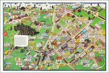
New Haven in 1928
Striking large view of New Haven, published by the Edward Judd Company of New Haven in 1928.
The map tells the story of New Haven in a series of historical vignettes arranged around the central map image, beginning with the founding of the city in 1638.
At the right is an unusual map illustrating "Pres. Stiles Map of British Attack", a rare depiction of this skirmish during the American Revolution
Other sites noted:
- Bethany Airdrome (in upper left just beyond Westville)
- West Rock Park
- Phipps Polo Field
- Grove Street Cemetery
- Waterside Park
- Union Station
Several vignettes celebrate the history of Yale in New Haven. An inset map details the main buildings of the Yale campus at a transitional moment when the university was building (or about to build) a system of undergraduate residential colleges. The newly constructed Sterling Memorial Library is labeled.
Other Yale buildings of note identified on the inset map:
- Old Campus: Vanderbilt Hall, Connecticut Hall, Bingham Hall, etc.
- Harkness Quadrangle
- Elizabethan Club
- Commons
- Book & Snake
- Scroll & Key
- Skull & Bones
- Wolf's Head
- Mory's
- Nathan Hale statue
This would seem to be the only map drawn by the artist, Carina Eaglesfield Mortimer, who would go on to a successful career as an architect.
Carina Eaglesfield Mortimer Milligan was an American architect.
Most of her work was as a designer of houses. She also worked in the Comite Americain de Secour Civil in France.