|
||

|

|
|

|
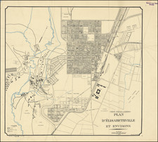
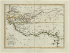
Mapping The Katanga Region of the Belgian Congo
Seven separately published maps of the Katanga District in the Belgian Congo, published by the Comite Special du Katanga.
The note on the verso of one of the sheets states:
Published by the Special Committee of Katanga, according to the surveys of its Geographical and Geological Service carried out from 1928 to 1929 and from 1932 to 1934.
The Katanga Map is divided into sheets (area of 1º square) each comprising three sheets; a topographical chart, a surface area chart and a subsoil geology chart.
Katanga District
The Katanga District was a mining district in the Belgian Congo. The region was known as a source of coppy from more than 1000 years.
In the 1890s, the region was under constant pressure from the south by Cecil Rhodes' Northern Rhodesia, and from the north by the Belgian Congo, the personal possession of King Leopold II of Belgium. Msiri, the King of Katanga, held out against both, but eventually Katanga was subsumed by the Belgian Congo. After 1900, the Societe Generale de Belgique practically controlled all of the mining in the province through Union Minière du Haut Katanga (UMHK). This included uranium, radium, copper, cobalt, zinc, cadmium, germanium, manganese, silver, gold, and tin.
In 1915 a deposit of pitchblende and other uranium minerals of a higher grade than had ever been found before anywhere in the world and higher than any found since were discovered at Shinkolobwe. The discovery was kept secret by UMHK. After WWI ended a factory was built at Olen and the secrecy was lifted at the end of 1922 with the announcement of the production of the first gram of radium the pitchblende. By the start of WWII, the mining companies "constituted a state within the Belgian Congo". The Shinkolobwe mine by Jadotville (now Likasi) was at the center of the Manhattan Project.
Hubert Droogmans and the Katanga District
Maria Franciscus Andreas Hubertus (Hubert) Droogmans (1858 - 1938 ) was a Belgian politician and senior official of the Congo Free State, which was privately owned by King Leopold II and the Belgian Congo.
After working briefly in the Belgian Consulate in Philadelphia, began work in the Finance Department of the Congo Free State in 1885. Droogmans became Secretary-General there in September 1894. He remained Secretary-General until the dissolution of the Congo Free State in 1908. He would serve in the same position in the Belgian Congo until 1911.
In the meantime, the Spécial du Katanga Committee (CSK) was founded in 1900. The task of this committee was to ensure the colonization and development of the mining province of Katanga, which was added to the Congo Free State as a new area. Droogmans was appointed as the very first chairman and would remain so until 1929. In 1904, under the impetus of Hubert Droogmans, the first maps from Katanga appeared.
In 1906, King Leopold II, together with Droogmans and Jean Jadot of the General Society of Belgium, founded the three sister companies Union Minière du Haut Katanga, Fominière and the Compagnie du chemin de fer du Bas-Congo au Katanga that would form the largest part of the Congolese economy to control.new agricultural techniques and had model farms built. He was responsible for setting up a parish and co-financed the construction of the first church in 1909.