|
||

|

|
|

|
Poole's 1856 Map of the Pueblo Lands of San Diego - With Unique Texas and Pacific Railroad Updates
Accompanied by an Unrecorded 1872 Manuscript Report on San Diego Harbor
"The climate of this port is simply delightful."
The present map and 1872 report on San Diego, newly discovered unique manuscripts, relate to San Diego's quest for a railroad connection in the early 1870s. Together they shed light on the active promotion of the city as a nexus of Pacific commerce in the early 1870s, with H. J. O'Reilly's report linking the terrestrial connection planned by the Texas and Pacific Railroad with the potential of San Diego's harbor as a major commercial port set to trade with Asia and Australia.
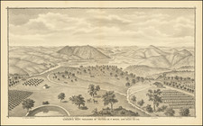
The large and impressive pen and ink map of San Diego is a unique updated manuscript rendition of Charles H. Poole's foundational San Diego Pueblo Lands map. The beautifully executed manuscript map is based on the printed version of Poole's map lithographed by Britton & Rey in San Francisco in 1856, but here with notable additions and updates likely relating to the proposed Texas and Pacific Railroad. Poole's map was the first Official Map of the Pueblo Lands of San Diego and was the map used in 1856 by the City Trustees in conveying lands to the San Diego & Gila, Southern Pacific & Atlantic Railroad (organized in 1854). Indeed, Poole's work in compiling the map was partly funded by that early railroad project and Poole was a shareholder in the company. The present circa 1872 version is accompanied by an unpublished manuscript report describing San Diego harbor, comprising 10 full pages, signed by Capt. H. J. O'Reilly, former Pilot Commissioner at San Francisco. The report is dated at San Francisco on September 19, 1872, suggesting a connection with active negotiations between San Diego leaders and the Texas and Pacific.
At first glance, it might seem curious that the Poole map - by then known within San Diego's inner circles for its inaccuracies - would be the choice to accompany O'Reilly's 1872 report. James Pascoe had produced an accurate map of San Diego Pueblo Lands - based on his own survey work - which replaced Poole's as the official map in 1870. But the choice of Poole's map makes sense given its foundational status within the context of the city's dealings with railroads. Poole's was the go-to map for railroad land concessions in San Diego going back to the 1850s and the San Diego & Gila - the very concessions avidly sought by the Texas & Pacific in 1872.
The saga of San Diego's quest for a railroad reads like a twisted Gilded Age drama, involving very real robber barons such as the Central Pacific's Charles Crocker and Collis Huntington, as well as self-serving businessmen from all quarters, including the local variety. San Diego would eventually pin its hopes of railroad-powered prosperity on Col. Tom Scott, president of the powerful Pennsylvania Railroad. Who better to wine and dine Washington power brokers and start a war with the Central Pacific? But the Panic of 1873 hit Wall Street, the railroad bubble burst, and the Paris-based bankers Scott relied upon withdrew their financing. In the end the city lost significant tracts of valuable land and got very little in return, as local leaders fell victim to economic forces beyond their control, squashing San Diego's last chance at becoming the major Southern California rail terminus.
Capt. H. J. O'Reilly's Hydrographic Report on San Diego Harbor
The present neatly handwritten report is signed by Capt. H. J. O'Reilly, who had previously served as Pilot Commissioner and Port Warden in San Francisco from about 1869 to 1872. While not much is known about O'Reilly, the Journal of the California Senate records that Gov. H. H. Haight nominated him for the position of Port Warden of San Francisco on Jan. 10, 1868. As the official responsible for the overall management and safety of the port, the Port Warden would have had a crucial role overseeing activities related to shipping, trade, and navigation within the harbor. This experience would have given Capt. O'Reilly an insider's view of the relative merits of the harbors of San Francisco and San Diego. The report emphasizes San Diego's natural proximity to the "South and West of the United States," as an ideal commercial nexus joining the southern states, Southern California, and Asia. In fact, O'Reilly's report shines a bright light on San Diego's advantages (over San Francisco here, rather than Los Angeles) as a commercial port that could dominate the vast Asiatic trade of the Pacific, including with Australia.
Excerpts from O'Reilly's text:
The Harbor of San Diego appears to have been designed by an All Wise Providence, in the economy of the globe, as the great entrepot for the interchange and distribution of the products of a great portion of the eastern and western hemisphere amongst the civilized community that inhabit them... Its advantages in these respects, over the harbor of San Francisco, a port that I know from personal experience, has but few equals on the shores of the great ocean, are very decided.
The proximity, too, of San Diego to the navigable waters of the Mississippi and its tributarys [sic], the great natural current for trade and commerce of the South and West of the United States; the easy grade of the line of railroad, the Texas Pacific, soon to connect San Diego with this current, and the comparative shortness of this line, and its situation below the snow zone, justify this conclusion.
As a sea captain, O'Reilly understandably highlights the advantages of San Diego's harbor as a connection to the East, including Japan and Australia:
Sailing ships bound to San Diego from Japan, China, East Indies or Oceanica seek the prevailing westerly winds north of the calm belt of Cancer, between the parallels of 37 degrees and 45 degrees, with which they run down their easting, by "composite sailing." The route from San Diego to Syndey or Melbourne, the principal ports of Australia, is as pleasant an ocean voyage as can well be imagined with either steam or sail... The writer made the passage from San Francisco to Syndey in 38 days, and to Melbourne in 44 days, in a sailing ship, and it can be made from San Diego to Syndey, under steam, in 24 days.
The September 1872 date on O'Reilly's report, as well as the explicit reference in the text itself to the planned Texas railroad, suggests a purpose for both map and report likely related to the Texas and Pacific project. The railroad's president, Thomas Scott, personally visited San Diego in August 1872 to seal a deal with local big wigs. Scott extolled San Diego's potential as a Pacific trade port based on the natural position and qualities of the city's harbor. Read Scott's own words as printed in a promotional pamphlet held in the U.C. San Diego Special Collections library, which appear under the heading: The Trade of the Orient:
On the completion of the Texas Pacific Railway, along the 32d parallel, the bulk of the traffic between the States east of the Mississippi and the Asiatic Empires, and also the fast freight between European and Asiatic ports, must of necessity pass through San Diego, and make this the Pacific coast port of trans-shipment... The introduction of Chinese labor in the Southern States...will add greatly to the traffic which must pass through San Diego between these States and the Orient... The commerce between European and Asiatic ports will add much to the business of the Texas Pacific Railroad -- San Diego, Southern California. The Pacific Terminus of the Texas Pacific Railroad (1872), page 3.
In order to achieve his plan, Scott demanded that his Texas and Pacific receive all lands held by the old San Diego & Gila Railroad, plus the usual rights of way through the city, and valuable waterfront concessions.
According to Harry C. Hopkins, who had served as a Deputy City Attorney in charge of land title litigation and authored an important book on San Diego's Pueblo Lands:
Col. Tom Scott came west [in August 1872] with a party of railroad men and success seemed assured. The visitors demanded of the City for their railroad right of way a site near the Court House for a terminal and 100 acres of water front land. The lands, 8606 acres, and about 50 City lots, were transferred to James A. Evins at $1.00 per parcel. The lands were worth probably $5,000,000. Evins in turn deeded the lands to the Texas Pacific Railroad Company... The unsuspecting citizens who had not understood the scheme were greatly stunned over the loss of their money and the road. All except the city officials are still inquiring about the loss of the Pueblo Lands.
An intriguing coda to O'Reilly's report is the inclusion of a final paragraph concerning Magdalena Bay in Baja California. In 1872, Magdalena Bay became the center of international controversy when Drake De Kay, a representative of a group of American investors, attempted to establish a colony after taking over a concession from the Mexican government. The endeavor aimed to develop an agricultural and commercial haven but quickly failed due to legal and financial difficulties. De Kay's presence and actions in Magdalena Bay stirred diplomatic tensions, as Mexico was wary of American expansionism, especially after territorial losses to the United States resulting from the 1846-48 Mexican War. The incident caught the attention of authorities in San Diego and the U.S. government, raising concerns over sovereignty and foreign policy in the region. Given this context, O'Reilly's reference to a "safe, capacious and commodious harbor" in Baja California, which could be "a useful adjunct" to San Diego, might be seen as an attempt to attract hyper-expansionist Americans to invest in the Texas & Pacific, particularly southerners, who had long seen Baja California as a logical extension of the United States's Pacific coast. Ultimately, the failed colony at Magdalena Bay highlighted the complexities of international relations and expansionist ambitions in the late 19th century and helped squash expansionist designs on the Baja California peninsula.
Background: The Texas and Pacific Railroad and San Diego's Pueblo Lands
In the years following the Civil War, San Diego envisioned a prosperous future as the western terminus of a transcontinental railroad. Like many other western cities at the time, San Diego saw the advent of rail connections as the key to growth, increased commerce, and rising property values. By 1872, after a few earlier aborted railroad projects, San Diegans set their sights on the Texas and Pacific Railroad, which proposed a route along the 32nd parallel. This route was favored by many San Diegans before the Civil War but had been stalled due to sectional tensions and the war itself.
The push for a rail connection in San Diego began as early as the 1850s, culminating in the formation of the San Diego and Gila, Southern Pacific and Atlantic Railway Company in 1854. The company's officers, who were among San Diego's wealthiest and most prominent residents, convinced the city to donate over 8000 acres of land, including valuable waterfront properties, to aid in the railroad's construction and operation. Despite reorganization and efforts to raise funds, the connection remained a pipe dream until the Memphis and El Paso Railroad agreed to take over the franchises and privileges of the San Diego & Gila in a stock exchange deal. However, the collapse of the Memphis and El Paso in 1870 left San Diego continuing its quest for an eastern rail connection.
Enter Tom Scott's Texas and Pacific. San Diego's hope for the Texas and Pacific Railroad was intertwined with Southern states' interests, as they too sought post-Civil War economic development. The proposed railroad was seen as a Reconstruction tool, a means to rejuvenate the South and connect it with the West. Charles Poole's 1856 map of the Pueblo Lands of San Diego, which had been used by the San Diego Board of Trustees in conveying lands to the San Diego and Gila Railroad, continued to play a pivotal role in these developments, serving as a vital reference for land grants and potential railway routes. Poole had been one of the original stockholders of the San Diego and Gila, and despite the existence of Pascoe's improved map, the Poole map remained the go-to for the land-hungry Texas railroad.
The Texas and Pacific Railroad was chartered by Congress in 1871, with the expectation that construction would commence simultaneously from San Diego and Marshall, Texas. However, the project was plagued with difficulties, including national economic crises and political complications. Despite overwhelming initial support, the Texas and Pacific Railroad's passage through San Diego was hindered by competing interests from the Central and Southern Pacific Railroads, which saw the new railroad as a threat to their monopoly.
Ultimately, the failure of the Texas and Pacific Railroad to reach San Diego was a result of forces beyond the city's control, including a national shift against land grants for railroads and the economic panic of 1873. San Diego's dream of becoming a railroad hub was deferred, and it was not until later years that the city would finally be connected by rail to the rest of the nation. Despite the setbacks, the efforts and hopes invested in the Texas and Pacific Railroad highlight San Diego's ambitious vision for its future and its place in the broader narrative of American expansion and development during the Reconstruction era.
Poole's Map of San Diego Pueblo Lands
Charles H. Poole, U.S. Deputy Surveyor, was commissioned to make a map of the pueblo lots in San Diego, whereby the city and the San Diego & Gila Railroad were to select alternative lots until the two leagues for the railroad had been identified. The cost of the survey mapping was split between the Trustees and the railroad. The San Diego Board of Trustees accepted Poole's plan as the official map of San Diego in September 1856. Poole's map was largely based on the work of earlier surveyors, and reportedly incorporated several inaccuracies, which were later rectified after litigation brought the errors to light. By 1870 San Diego adopted a new Official Map based on surveys by James Pascoe.
In 1856 land was protracted on Poole's Map as based on known information; it was not the results [sic] of a survey by Poole. Since La Playa, New San Diego, Old Town and Middletown were shown on the map, they were then existing.... Mission Valley was plotted a half mile out of position. This resulted in the court case of Cleveland v. Choate in June of 1888... During the trial the following facts came out: In 1856 Charles H. Poole prepared a map of the Pueblo Lands of the city of San Diego, lying between what is known as New San Diego in said city and the Mission Valley, composing a strip of several miles, running from the bay of San Diego back to the eastern limits of the city. The map was for some years thereafter, until 1868, the official map of these pueblo lots, and was supposed to be correct until the surveys made by James Pascoe, County Surveyor, Dec. 6, 1867, June 12, 1868 and July 1, 1868, which demonstrated its incorrectness, and resulted in the making and adoption of the Pascoe map as the official map, in Aug. 1870 - Brown & Pallamary, History of San Diego Land Surveying Experiences.
Updates to the Poole Map
We note several differences between our manuscript map and the 1856 Britton & Rey version, chiefly the addition of a red line for the proposed route of the Texas and Pacific Railroad. Another standout quality is the handsome wash color on our map. Also the light-pink coloring on approximately 50 pueblo lots - likely indicating land concessions to the railroad.
- A red line tracks the proposed Texas & Pacific rail route - present on our map, but not on the Britton & Rey.
- Small yellow sections on scattered Pueblo Lots, possibly indicating additional concessions to the Railroad.
- Inclusion of the "large numbers" to identify Pueblo Lots only, i.e. omitting the older survey lot numbers found on the Britton & Rey map.
Rarity
O'Reilly's report appears to be unique, with no other example, printed or manuscript, recorded in OCLC or in any standard California or San Diego bibliography. Poole's map is very rare in any 19th-century iteration, with only two examples of the 1856 Britton & Rey version located in OCLC, those held at the Bancroft and the University of Washington. The Bancroft also holds a manuscript version of the Poole map, which is described in detail by Harlow, under his entry no. 37, but our manuscript map seems based on the Britton & Rey lithograph map (Harlow 38), with the addition of later information described above.
![(National City & Otay Railway) Plat of the located lines of the Tia Juana & Oneonta Branches of the Otay Railway [with] Plat of the National City & Otay Railway Sheet 2 from South Line of San Diego to Otay City [with] Plat of the National City & Otay Railway Sheet 3 from Sweetwater Junction to La Presa](https://storage.googleapis.com/raremaps/img/small/96209.jpg)

![(California Photographs) [Album of 112 original photographs: San Diego and Los Angeles area, including La Jolla - Coronado - Sunset Cliffs - Lake Cuyamaca - Cuyamaca Dam & Valley -- Tia Juana (San Ysidro) -- Raymond Hotel in Pasadena - Shasta - Lick Observatory - Seattle]](https://storage.googleapis.com/raremaps/img/small/98892.jpg)
![[ Before The Salton Sea ] [ Official Map of San Diego County compiled from latest official maps of U.S. surveys, railroad and irrigation surveys, county records, and other reliable sources . . . Northeast Sheet ]](https://storage.googleapis.com/raremaps/img/small/101378.jpg)